

Naggler Alm Runde Weissensee - Naggler Alm Runde Weissensee
A cycling route starting in Steinfeld, Carinthia, Austria.
Overview
About this route
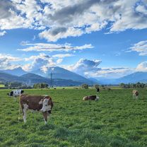
Beautiful tour with views of the Naggler Nock.
- -:--
- Duration
- 15.6 km
- Distance
- 736 m
- Ascent
- 734 m
- Descent
- ---
- Avg. speed
- 1,381 m
- Max. altitude
Route quality
Waytypes & surfaces along the route
Waytypes
Track
11 km
(70 %)
Quiet road
0.5 km
(3 %)
Surfaces
Paved
0.6 km
(4 %)
Unpaved
11.3 km
(72 %)
Gravel
9.9 km
(63 %)
Loose gravel
0.8 km
(5 %)
Continue with Bikemap
Use, edit, or download this cycling route
You would like to ride Naggler Alm Runde Weissensee - Naggler Alm Runde Weissensee or customize it for your own trip? Here is what you can do with this Bikemap route:
Free features
- Save this route as favorite or in collections
- Copy & plan your own version of this route
- Sync your route with Garmin or Wahoo
Premium features
Free trial for 3 days, or one-time payment. More about Bikemap Premium.
- Navigate this route on iOS & Android
- Export a GPX / KML file of this route
- Create your custom printout (try it for free)
- Download this route for offline navigation
Discover more Premium features.
Get Bikemap PremiumFrom our community
Other popular routes starting in Steinfeld
 Weißensee
- Distance
- 16.1 km
- Ascent
- 162 m
- Descent
- 163 m
- Location
- Steinfeld, Carinthia, Austria
 2. Tag Steinfeld - Feistritz
- Distance
- 54.1 km
- Ascent
- 187 m
- Descent
- 326 m
- Location
- Steinfeld, Carinthia, Austria
 von Kleblach-Lind nach Unterkolbnitz
- Distance
- 44 km
- Ascent
- 549 m
- Descent
- 549 m
- Location
- Steinfeld, Carinthia, Austria
 Short ride from Weißensee to Techendorf
- Distance
- 5.8 km
- Ascent
- 197 m
- Descent
- 580 m
- Location
- Steinfeld, Carinthia, Austria
 Techendorf 96, Weissensee a Urbeleweg, Stockenboi
- Distance
- 32 km
- Ascent
- 660 m
- Descent
- 644 m
- Location
- Steinfeld, Carinthia, Austria
 Weißensee Kohlrösselhütte Kreuzberg Hermagor
- Distance
- 46.7 km
- Ascent
- 1,084 m
- Descent
- 1,509 m
- Location
- Steinfeld, Carinthia, Austria
 Steinfeld - Spittal an der Drau
- Distance
- 23.1 km
- Ascent
- 216 m
- Descent
- 246 m
- Location
- Steinfeld, Carinthia, Austria
 KäS3: Weissensee-Gödersdorf; 71,3km 360hm
- Distance
- 74.4 km
- Ascent
- 554 m
- Descent
- 952 m
- Location
- Steinfeld, Carinthia, Austria
Open it in the app