
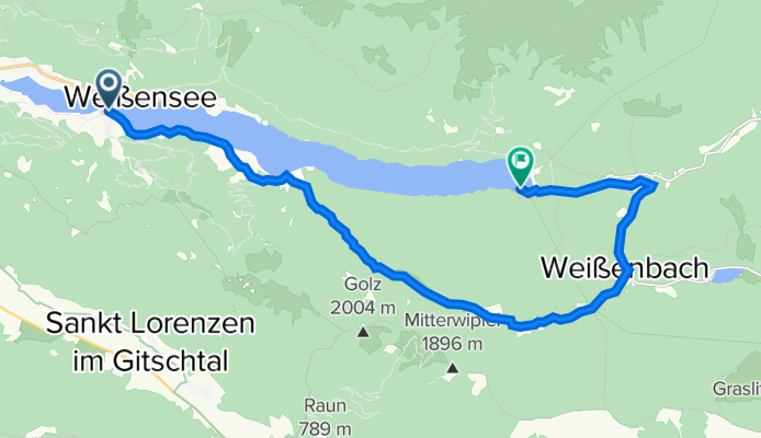
Bodenalm - Ostufer - mit dem Schiff zurück - Weissensee - Bodenalm - Ostufer - mit dem Schiff zurück - Weissensee
A cycling route starting in Steinfeld, Carinthia, Austria.
Overview
About this route
Herrliche Mountainbiketour mit einigen Einkehrmöglichkeiten, wie die 'Hermagorer Bodena
- -:--
- Duration
- 19.1 km
- Distance
- 663 m
- Ascent
- 648 m
- Descent
- ---
- Avg. speed
- 1,256 m
- Max. altitude
Route quality
Waytypes & surfaces along the route
Waytypes
Track
9.8 km
(51 %)
Busy road
3.8 km
(20 %)
Surfaces
Paved
2.3 km
(12 %)
Unpaved
12.5 km
(65 %)
Gravel
12.5 km
(65 %)
Asphalt
2.3 km
(12 %)
Undefined
4.3 km
(22 %)
Continue with Bikemap
Use, edit, or download this cycling route
You would like to ride Bodenalm - Ostufer - mit dem Schiff zurück - Weissensee - Bodenalm - Ostufer - mit dem Schiff zurück - Weissensee or customize it for your own trip? Here is what you can do with this Bikemap route:
Free features
- Save this route as favorite or in collections
- Copy & plan your own version of this route
- Sync your route with Garmin or Wahoo
Premium features
Free trial for 3 days, or one-time payment. More about Bikemap Premium.
- Navigate this route on iOS & Android
- Export a GPX / KML file of this route
- Create your custom printout (try it for free)
- Download this route for offline navigation
Discover more Premium features.
Get Bikemap PremiumFrom our community
Other popular routes starting in Steinfeld
 von Kleblach-Lind nach Unterkolbnitz
- Distance
- 44 km
- Ascent
- 549 m
- Descent
- 549 m
- Location
- Steinfeld, Carinthia, Austria
 Weissensee - Glockner (Hochtor) und retour
- Distance
- 96.7 km
- Ascent
- 2,388 m
- Descent
- 828 m
- Location
- Steinfeld, Carinthia, Austria
 Weißensee
- Distance
- 16.1 km
- Ascent
- 162 m
- Descent
- 163 m
- Location
- Steinfeld, Carinthia, Austria
 A_Rund um den Weißensee
- Distance
- 14.6 km
- Ascent
- 63 m
- Descent
- 63 m
- Location
- Steinfeld, Carinthia, Austria
 auf dem Drauradweg von Kleblach-Lind nach Dellach
- Distance
- 59 km
- Ascent
- 745 m
- Descent
- 745 m
- Location
- Steinfeld, Carinthia, Austria
 Techendorf 96, Weissensee a Urbeleweg, Stockenboi
- Distance
- 32 km
- Ascent
- 660 m
- Descent
- 644 m
- Location
- Steinfeld, Carinthia, Austria
 R3 ab Hotel 25km 360HM Boot zurück
- Distance
- 25.8 km
- Ascent
- 422 m
- Descent
- 428 m
- Location
- Steinfeld, Carinthia, Austria
 Short ride from Weißensee to Techendorf
- Distance
- 5.8 km
- Ascent
- 197 m
- Descent
- 580 m
- Location
- Steinfeld, Carinthia, Austria
Open it in the app