

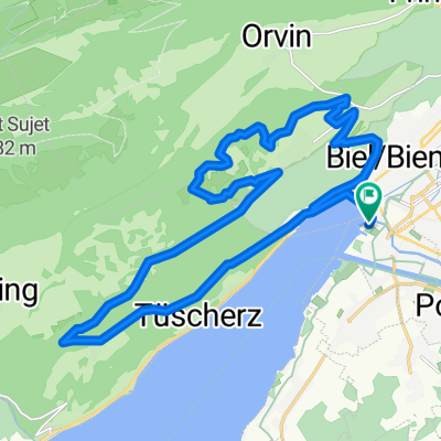
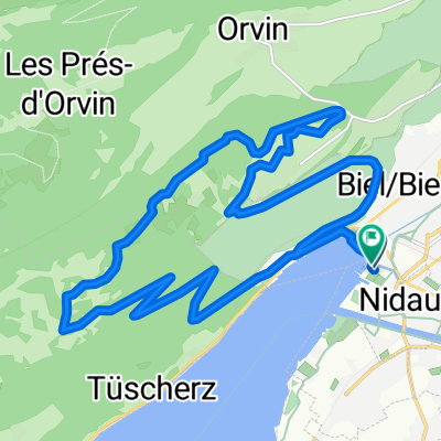
Berner Roadstory von Biel über den Frienisberg
A cycling route starting in Nidau, Canton of Bern, Switzerland.
Overview
About this route
Listen to the text here
If you were to trust the rain radar, I should already be standing inside a thunderstorm cell. I set off, exiting Biel from the back of the station, with the wind at my back. Over the bridge to the other side of the Nidau-Büren Canal, immediately sharp right down to the lakeshore. The bike path leads over the first gravel stretch towards Hagneck, past the cheeky goats of the Von Rüte farm, past the cherry orchards and down to the lake.
At the Hagneck power plant, the road climbs up over the hill into the village, momentarily raising the pulse, out of the saddle pedaling, beads of sweat on the forehead. The reward: a great panoramic view of the Frienisberg, the destination of the journey.
I follow the Aare canal to Aarberg, still with tailwind, flat terrain, straight road, the second part on gravel, pushing the speed. At the village entrance, I follow bike route No. 8, cross the Aare and continue towards Niederried. Just before the village entrance, sharp right over the small bridge up into the village. Further up to Golaten, passing vegetable fields, then down to the Saane river.
Over the Saane footbridge back to the Aare, on the horizon the decommissioned Mühleberg nuclear power plant appears, in the foreground a charming floodplain landscape, a family of swans taking their young out for a stroll. For some, the future begins here; for others, the past is erased. I continue on to the power plant across the weir, left up onto Salvisberg, 18% gradient, burning legs, pulse at its limit. Charming Bernese farmhouses with red geraniums in the windows, proud cows, and secretly grinning donkeys.
A long climb leads me to Frieswil, a hundred meters higher, a quick water refill at the fountain, at Stöckli left over the main road out of the village. The sign reads Route 890 Frienisberg panoramic route.
The red kite pair circles over the valley. My gaze sweeps over the three lakes glittering turquoise in the sun, in the distance on the horizon the Creux du Vent is visible. Between the panorama and me, a rain front like a white curtain softens the lovely landscape. A postal bus winds through the villages below me. From a distance, the world down there seems in order.
I continue on to Dampfwil, a short climb into Bagwillgraben, down to Frienisberg. Before the retirement home I turn right and immediately left towards Schüpfen. A fast descent through golden cornfields, past scattered hamlets. At the brickyard I turn left onto Route 64 towards Biel. Cross the motorway and reach Suberg, past the legendary railway crossing, along the main road to Lyss, pushing speed again.
At the roundabout at the village entrance, the route leaves the main road and leads through small streets in the village. Through the industrial area towards Studen, the first drops fall. At the roundabout in front of the station I briefly brush against the evening rush hour traffic, I escape through residential streets, across fields to Aegerten and follow the canal to Brügg.
From here you can continue straight back to Biel. I take the route over the bridge, at the village entrance stands the Meier bakery, on Mondays they have Aroser rolls, childhood memories and sugar for the final sprint to Biel.
- -:--
- Duration
- 69.3 km
- Distance
- 811 m
- Ascent
- 811 m
- Descent
- ---
- Avg. speed
- 709 m
- Max. altitude

Route photos


Route quality
Waytypes & surfaces along the route
Waytypes
Quiet road
42.2 km
(61 %)
Track
13.2 km
(19 %)
Surfaces
Paved
37.4 km
(54 %)
Unpaved
11.8 km
(17 %)
Asphalt
34.6 km
(50 %)
Loose gravel
4.8 km
(7 %)
Route highlights
Points of interest along the route
Point of interest after 4.4 km
Von Rüte Gut
Point of interest after 30.2 km
Zukunft und Vergangenheit

Point of interest after 34.4 km
Point of interest after 52.1 km
Bahnübergang
Point of interest after 63.7 km
Bäckerei Meier
Continue with Bikemap
Use, edit, or download this cycling route
You would like to ride Berner Roadstory von Biel über den Frienisberg or customize it for your own trip? Here is what you can do with this Bikemap route:
Free features
- Save this route as favorite or in collections
- Copy & plan your own version of this route
- Sync your route with Garmin or Wahoo
Premium features
Free trial for 3 days, or one-time payment. More about Bikemap Premium.
- Navigate this route on iOS & Android
- Export a GPX / KML file of this route
- Create your custom printout (try it for free)
- Download this route for offline navigation
Discover more Premium features.
Get Bikemap PremiumFrom our community
Other popular routes starting in Nidau
 Biennathlon 2010 - Inline
- Distance
- 14.9 km
- Ascent
- 63 m
- Descent
- 62 m
- Location
- Nidau, Canton of Bern, Switzerland
 Alexander-Moser-Strasse nach Alexander-Moser-Strasse
- Distance
- 12.8 km
- Ascent
- 81 m
- Descent
- 123 m
- Location
- Nidau, Canton of Bern, Switzerland
 Nidau-Frienisberg
- Distance
- 45.4 km
- Ascent
- 459 m
- Descent
- 459 m
- Location
- Nidau, Canton of Bern, Switzerland
 Biennathlon 2011 Bike (25 km / 860 m up)
- Distance
- 25.3 km
- Ascent
- 871 m
- Descent
- 869 m
- Location
- Nidau, Canton of Bern, Switzerland
 Biel Chasseral
- Distance
- 48.9 km
- Ascent
- 1,511 m
- Descent
- 1,510 m
- Location
- Nidau, Canton of Bern, Switzerland
 Biennathlon Bikestrecke 2008 CLONED FROM ROUTE 47247
- Distance
- 23.2 km
- Ascent
- 880 m
- Descent
- 878 m
- Location
- Nidau, Canton of Bern, Switzerland
 Grosse Bielerseerunde
- Distance
- 62 km
- Ascent
- 254 m
- Descent
- 250 m
- Location
- Nidau, Canton of Bern, Switzerland
 Haller: Ipsach - Solothurn - Ipsach
- Distance
- 65.5 km
- Ascent
- 120 m
- Descent
- 118 m
- Location
- Nidau, Canton of Bern, Switzerland
Open it in the app