

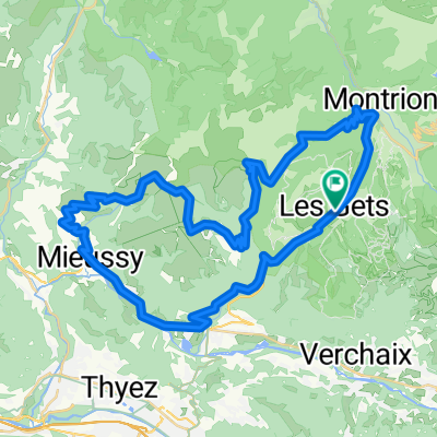
joux plane - joux verte - col de l'encrenaz
A cycling route starting in Les Gets, Auvergne-Rhône-Alpes, France.
Overview
About this route
Almost from the top of Col de l'encrenaz via Taninges to the foot of Joux Plane at Samoens. Then via Joux Plane to Morzine and directly further to Joux Verte. Back in Morzine, back up to Col de l'encrenaz. The descent from Joux Plane is incorrect, as the navigation does not accept the bridges over the water. However, this is one big road, so despite the deviations in the route guidance, just keep following the road.
- -:--
- Duration
- 86.7 km
- Distance
- 2,857 m
- Ascent
- 2,858 m
- Descent
- ---
- Avg. speed
- 1,757 m
- Max. altitude

Route quality
Waytypes & surfaces along the route
Waytypes
Road
49.4 km
(57 %)
Quiet road
4.3 km
(5 %)
Surfaces
Paved
68.5 km
(79 %)
Unpaved
5.2 km
(6 %)
Asphalt
65.9 km
(76 %)
Concrete
2.6 km
(3 %)
Continue with Bikemap
Use, edit, or download this cycling route
You would like to ride joux plane - joux verte - col de l'encrenaz or customize it for your own trip? Here is what you can do with this Bikemap route:
Free features
- Save this route as favorite or in collections
- Copy & plan your own version of this route
- Split it into stages to create a multi-day tour
- Sync your route with Garmin or Wahoo
Premium features
Free trial for 3 days, or one-time payment. More about Bikemap Premium.
- Navigate this route on iOS & Android
- Export a GPX / KML file of this route
- Create your custom printout (try it for free)
- Download this route for offline navigation
Discover more Premium features.
Get Bikemap PremiumFrom our community
Other popular routes starting in Les Gets
 Les Gets - Ramaz - Encrenaz
- Distance
- 56.3 km
- Ascent
- 1,437 m
- Descent
- 1,434 m
- Location
- Les Gets, Auvergne-Rhône-Alpes, France
 Tour du Mont-Chéry
- Distance
- 39.3 km
- Ascent
- 902 m
- Descent
- 900 m
- Location
- Les Gets, Auvergne-Rhône-Alpes, France
 2017 Alps 1
- Distance
- 112.9 km
- Ascent
- 2,874 m
- Descent
- 2,864 m
- Location
- Les Gets, Auvergne-Rhône-Alpes, France
 6. Etappe: Les Gets - Col des Aravis
- Distance
- 65.8 km
- Ascent
- 1,668 m
- Descent
- 1,605 m
- Location
- Les Gets, Auvergne-Rhône-Alpes, France
 Les Gets - Samoens - Joux Plane - Encrenaz
- Distance
- 65.8 km
- Ascent
- 1,663 m
- Descent
- 1,661 m
- Location
- Les Gets, Auvergne-Rhône-Alpes, France
 Les Gets-Col La Joux Verte Montriond -Les Gets
- Distance
- 41.3 km
- Ascent
- 1,057 m
- Descent
- 1,062 m
- Location
- Les Gets, Auvergne-Rhône-Alpes, France
 2017 Alps 2
- Distance
- 151.8 km
- Ascent
- 3,852 m
- Descent
- 4,052 m
- Location
- Les Gets, Auvergne-Rhône-Alpes, France
 joux plane - joux verte - col de l'encrenaz
- Distance
- 86.7 km
- Ascent
- 2,857 m
- Descent
- 2,858 m
- Location
- Les Gets, Auvergne-Rhône-Alpes, France
Open it in the app