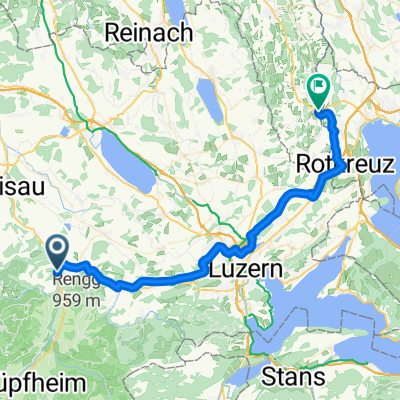
feierabendroute 2
A cycling route starting in Wolhusen, Canton of Lucerne, Switzerland.
Overview
About this route
schöne kurztour mit blick auf berner oberland , pilatus
Â
- -:--
- Duration
- 11.5 km
- Distance
- 362 m
- Ascent
- 354 m
- Descent
- ---
- Avg. speed
- ---
- Avg. speed
Continue with Bikemap
Use, edit, or download this cycling route
You would like to ride feierabendroute 2 or customize it for your own trip? Here is what you can do with this Bikemap route:
Free features
- Save this route as favorite or in collections
- Copy & plan your own version of this route
- Sync your route with Garmin or Wahoo
Premium features
Free trial for 3 days, or one-time payment. More about Bikemap Premium.
- Navigate this route on iOS & Android
- Export a GPX / KML file of this route
- Create your custom printout (try it for free)
- Download this route for offline navigation
Discover more Premium features.
Get Bikemap PremiumFrom our community
Other popular routes starting in Wolhusen
- Napf Marathon via Wolhusen Oberänzi
- Distance
- 45.4 km
- Ascent
- 1,270 m
- Descent
- 1,274 m
- Location
- Wolhusen, Canton of Lucerne, Switzerland
- Steinhuserberg-Menzberg-Willisau-Staechelegg
- Distance
- 49.6 km
- Ascent
- 1,050 m
- Descent
- 1,059 m
- Location
- Wolhusen, Canton of Lucerne, Switzerland
- wolhusen - glaubenberg
- Distance
- 21.9 km
- Ascent
- 964 m
- Descent
- 278 m
- Location
- Wolhusen, Canton of Lucerne, Switzerland
- Fontanne Pintli-Grämse-Romoos-Doppelschwand
- Distance
- 18.1 km
- Ascent
- 584 m
- Descent
- 584 m
- Location
- Wolhusen, Canton of Lucerne, Switzerland
- Stäfelialp
- Distance
- 43.3 km
- Ascent
- 1,064 m
- Descent
- 1,066 m
- Location
- Wolhusen, Canton of Lucerne, Switzerland
- Napf Radrunde
- Distance
- 52.1 km
- Ascent
- 798 m
- Descent
- 977 m
- Location
- Wolhusen, Canton of Lucerne, Switzerland
- De Menznauerstrasse 49, Wolhusen a Menznauerstrasse 49, Wolhusen
- Distance
- 33.3 km
- Ascent
- 155 m
- Descent
- 161 m
- Location
- Wolhusen, Canton of Lucerne, Switzerland
- Fontanne Pintli-Kleine Fontanne-Mättebergegg
- Distance
- 25.1 km
- Ascent
- 775 m
- Descent
- 775 m
- Location
- Wolhusen, Canton of Lucerne, Switzerland
Open it in the app