
Dambergrunde übers Windloch (Mountainbike)
A cycling route starting in Garsten, Upper Austria, Austria.
Overview
About this route
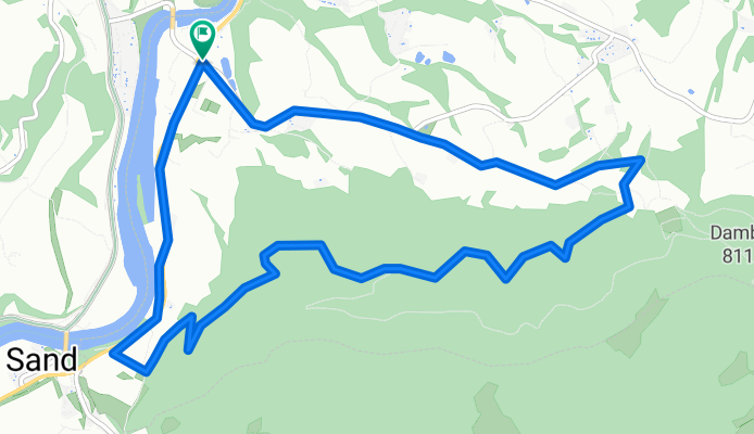
Diese Runde am Hausberg von Steyr ist der perfekte Ausgleich nach einem langen Arbeitstag. Die Strecke beginnt beim Kraftwerk Garsten und steigt steil auf wenig befahrenen Asphaltstraßen bis zum Gasthaus Schoiber auf. Ab dort geht aus auf der Forststraße steil weiter bis knapp unter die Dammbergwarte. Man fährt am Kamm entlang Richtung Windloch, um dann sehr steil bergab (Helm!!) zwischen Bäumen und über Wurzeln Richtung Gasthaus Eckhart abzufahren. Fahrtzeit ca. 1 Stunde.
- -:--
- Duration
- 10 km
- Distance
- 403 m
- Ascent
- 406 m
- Descent
- ---
- Avg. speed
- 622 m
- Max. altitude

Route quality
Waytypes & surfaces along the route
Waytypes
Track
4.7 km
(47 %)
Quiet road
2.4 km
(24 %)
Surfaces
Paved
3.4 km
(34 %)
Unpaved
5.5 km
(55 %)
Gravel
4.4 km
(44 %)
Asphalt
3.4 km
(34 %)
Continue with Bikemap
Use, edit, or download this cycling route
You would like to ride Dambergrunde übers Windloch (Mountainbike) or customize it for your own trip? Here is what you can do with this Bikemap route:
Free features
- Save this route as favorite or in collections
- Copy & plan your own version of this route
- Sync your route with Garmin or Wahoo
Premium features
Free trial for 3 days, or one-time payment. More about Bikemap Premium.
- Navigate this route on iOS & Android
- Export a GPX / KML file of this route
- Create your custom printout (try it for free)
- Download this route for offline navigation
Discover more Premium features.
Get Bikemap PremiumFrom our community
Other popular routes starting in Garsten
 Garsten - Sierning (Ortszentren, Umgehung von Hauptverkehrsstraßen)
- Distance
- 11.3 km
- Ascent
- 183 m
- Descent
- 114 m
- Location
- Garsten, Upper Austria, Austria
 Bergtraining
- Distance
- 75.2 km
- Ascent
- 1,213 m
- Descent
- 1,207 m
- Location
- Garsten, Upper Austria, Austria
 Steyrtalrunde
- Distance
- 97 km
- Ascent
- 895 m
- Descent
- 893 m
- Location
- Garsten, Upper Austria, Austria
 Saaß-Hedl-Garsten-Saaß
- Distance
- 19.6 km
- Ascent
- 425 m
- Descent
- 434 m
- Location
- Garsten, Upper Austria, Austria
 Saaß-Bankerl-Graben-Saaß
- Distance
- 7.3 km
- Ascent
- 194 m
- Descent
- 196 m
- Location
- Garsten, Upper Austria, Austria
 Christkindl-Pesendorf Runde
- Distance
- 10.5 km
- Ascent
- 225 m
- Descent
- 225 m
- Location
- Garsten, Upper Austria, Austria
 Route in Garsten
- Distance
- 36.8 km
- Ascent
- 1,124 m
- Descent
- 1,123 m
- Location
- Garsten, Upper Austria, Austria
 Schneeherrgott
- Distance
- 34.8 km
- Ascent
- 719 m
- Descent
- 716 m
- Location
- Garsten, Upper Austria, Austria
Open it in the app