
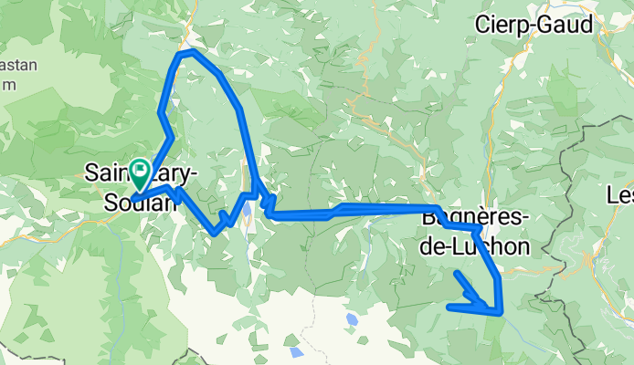
Saint Larye - Peyresourde - Superbagneres
A cycling route starting in Saint-Lary-Soulan, Occitanie, France.
Overview
About this route
Departure from Saint Larye, Col de Peyresourde, Superbagneres, Col de Peyresourde, Val-Louron. Especially tough is the Col de Peyresourde on the way back, it becomes a pain.
- -:--
- Duration
- 124.7 km
- Distance
- 3,412 m
- Ascent
- 3,412 m
- Descent
- ---
- Avg. speed
- ---
- Max. altitude
Continue with Bikemap
Use, edit, or download this cycling route
You would like to ride Saint Larye - Peyresourde - Superbagneres or customize it for your own trip? Here is what you can do with this Bikemap route:
Free features
- Save this route as favorite or in collections
- Copy & plan your own version of this route
- Split it into stages to create a multi-day tour
- Sync your route with Garmin or Wahoo
Premium features
Free trial for 3 days, or one-time payment. More about Bikemap Premium.
- Navigate this route on iOS & Android
- Export a GPX / KML file of this route
- Create your custom printout (try it for free)
- Download this route for offline navigation
Discover more Premium features.
Get Bikemap PremiumFrom our community
Other popular routes starting in Saint-Lary-Soulan
 10.08.07 Col d´Aspin
- Distance
- 42.3 km
- Ascent
- 1,284 m
- Descent
- 1,284 m
- Location
- Saint-Lary-Soulan, Occitanie, France
 Sait Lary Soulan-Col d´Azet-Col de Peyresourde-Bagnerés de Luchon-Col du Portillon-Arties
- Distance
- 86 km
- Ascent
- 2,487 m
- Descent
- 2,163 m
- Location
- Saint-Lary-Soulan, Occitanie, France
 11.08.07 Col de Peyresourde
- Distance
- 51.2 km
- Ascent
- 1,051 m
- Descent
- 1,051 m
- Location
- Saint-Lary-Soulan, Occitanie, France
 Saint-Lary-Soulan - Saint-Girons
- Distance
- 118.8 km
- Ascent
- 1,552 m
- Descent
- 2,016 m
- Location
- Saint-Lary-Soulan, Occitanie, France
 QV A2M S 4+5 (A)
- Distance
- 207.1 km
- Ascent
- 2,531 m
- Descent
- 2,958 m
- Location
- Saint-Lary-Soulan, Occitanie, France
 Pirenaica11. Saint-Lary-Soulan - Vielha
- Distance
- 105.3 km
- Ascent
- 2,737 m
- Descent
- 2,579 m
- Location
- Saint-Lary-Soulan, Occitanie, France
 Arreau, Hourquete d'Ancizan, Descenso por Col D'Aspin
- Distance
- 37.7 km
- Ascent
- 1,233 m
- Descent
- 1,233 m
- Location
- Saint-Lary-Soulan, Occitanie, France
 Etapa 1 Pirineos 2013 (144kms)
- Distance
- 144.1 km
- Ascent
- 0 m
- Descent
- 0 m
- Location
- Saint-Lary-Soulan, Occitanie, France
Open it in the app