

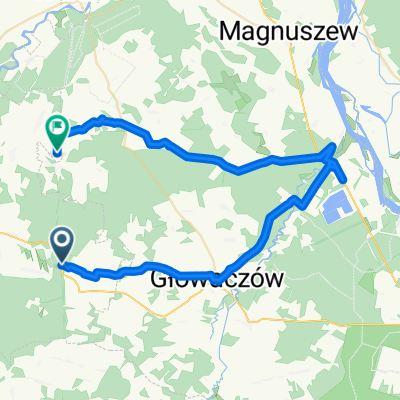
Henryków 11–12, Głowaczów do Adama Mickiewicza 2, Głowaczów
A cycling route starting in Stromiec, Masovian Voivodeship, Poland.
Overview
About this route
- 33 min
- Duration
- 8.9 km
- Distance
- 175 m
- Ascent
- 204 m
- Descent
- 16.1 km/h
- Avg. speed
- 163 m
- Max. altitude
Route quality
Waytypes & surfaces along the route
Waytypes
Quiet road
6.9 km
(78 %)
Pedestrian area
1.7 km
(20 %)
Surfaces
Paved
4.1 km
(46 %)
Unpaved
2.4 km
(27 %)
Asphalt
4.1 km
(46 %)
Gravel
1.6 km
(18 %)
Continue with Bikemap
Use, edit, or download this cycling route
You would like to ride Henryków 11–12, Głowaczów do Adama Mickiewicza 2, Głowaczów or customize it for your own trip? Here is what you can do with this Bikemap route:
Free features
- Save this route as favorite or in collections
- Copy & plan your own version of this route
- Sync your route with Garmin or Wahoo
Premium features
Free trial for 3 days, or one-time payment. More about Bikemap Premium.
- Navigate this route on iOS & Android
- Export a GPX / KML file of this route
- Create your custom printout (try it for free)
- Download this route for offline navigation
Discover more Premium features.
Get Bikemap PremiumFrom our community
Other popular routes starting in Stromiec
 Trasa umiarkowana
- Distance
- 20.1 km
- Ascent
- 180 m
- Descent
- 171 m
- Location
- Stromiec, Masovian Voivodeship, Poland
 50A, Podlesie Duże do Podlesie Duże
- Distance
- 12.1 km
- Ascent
- 60 m
- Descent
- 94 m
- Location
- Stromiec, Masovian Voivodeship, Poland
 Białobrzeska 170, Stromiec do 67A, Podlesie Duże
- Distance
- 14.9 km
- Ascent
- 185 m
- Descent
- 205 m
- Location
- Stromiec, Masovian Voivodeship, Poland
 Białobrzeska 156, Stromiec do Pietrusin 2, Stromiec
- Distance
- 8.5 km
- Ascent
- 22 m
- Descent
- 27 m
- Location
- Stromiec, Masovian Voivodeship, Poland
 Zabagnie 2–2A, Stromiec do Kasztelańska 11d, Radom
- Distance
- 27.7 km
- Ascent
- 91 m
- Descent
- 80 m
- Location
- Stromiec, Masovian Voivodeship, Poland
 Białobrzeski i kozienicki
- Distance
- 37.5 km
- Ascent
- 95 m
- Descent
- 107 m
- Location
- Stromiec, Masovian Voivodeship, Poland
 Główna, Dobieszyn do Boska Wola, Stromiec
- Distance
- 47.5 km
- Ascent
- 96 m
- Descent
- 121 m
- Location
- Stromiec, Masovian Voivodeship, Poland
 Gościniec Warecki do Podlesie Duże
- Distance
- 17.8 km
- Ascent
- 101 m
- Descent
- 111 m
- Location
- Stromiec, Masovian Voivodeship, Poland
Open it in the app