

Trainingseinheit Sasbachwalden
A cycling route starting in Sasbachwalden, Baden-Wurttemberg, Germany.
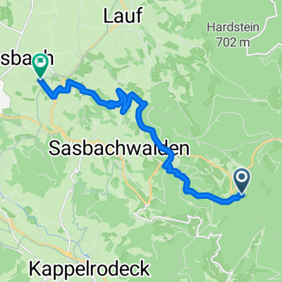
Overview
About this route
This is a relatively good opportunity to train longer climbs on relatively short routes. Uphill in about 39 min. Downhill in about 33 min
- -:--
- Duration
- 3 km
- Distance
- 432 m
- Ascent
- 14 m
- Descent
- ---
- Avg. speed
- 677 m
- Max. altitude
Continue with Bikemap
Use, edit, or download this cycling route
You would like to ride Trainingseinheit Sasbachwalden or customize it for your own trip? Here is what you can do with this Bikemap route:
Free features
- Save this route as favorite or in collections
- Copy & plan your own version of this route
- Sync your route with Garmin or Wahoo
Premium features
Free trial for 3 days, or one-time payment. More about Bikemap Premium.
- Navigate this route on iOS & Android
- Export a GPX / KML file of this route
- Create your custom printout (try it for free)
- Download this route for offline navigation
Discover more Premium features.
Get Bikemap PremiumFrom our community
Other popular routes starting in Sasbachwalden
 Pendlerroute
- Distance
- 17.5 km
- Ascent
- 72 m
- Descent
- 578 m
- Location
- Sasbachwalden, Baden-Wurttemberg, Germany
 Schwarzwald d'Huez
- Distance
- 11.9 km
- Ascent
- 830 m
- Descent
- 65 m
- Location
- Sasbachwalden, Baden-Wurttemberg, Germany
 BW-Achern2014-M-37km
- Distance
- 36.5 km
- Ascent
- 1,319 m
- Descent
- 1,323 m
- Location
- Sasbachwalden, Baden-Wurttemberg, Germany
 1991_Rheinebene mit Xenia
- Distance
- 39.6 km
- Ascent
- 132 m
- Descent
- 132 m
- Location
- Sasbachwalden, Baden-Wurttemberg, Germany
 Alpirsbacher Klosterbräu Schwarzwaldtrail
- Distance
- 10.2 km
- Ascent
- 64 m
- Descent
- 744 m
- Location
- Sasbachwalden, Baden-Wurttemberg, Germany
 1991_Schwarzwald_Hochstraße
- Distance
- 43.4 km
- Ascent
- 859 m
- Descent
- 859 m
- Location
- Sasbachwalden, Baden-Wurttemberg, Germany
 Steve Sasbachwalden 2024
- Distance
- 62.8 km
- Ascent
- 416 m
- Descent
- 413 m
- Location
- Sasbachwalden, Baden-Wurttemberg, Germany
 Achern - Hornisgrinde
- Distance
- 26 km
- Ascent
- 1,180 m
- Descent
- 1,178 m
- Location
- Sasbachwalden, Baden-Wurttemberg, Germany
Open it in the app