

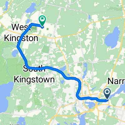
25 miles W C. O'Neill Bike Path Narragansett
A cycling route starting in Narragansett Pier, Rhode Island, United States.
Overview
About this route
- 1 h 44 min
- Duration
- 40.9 km
- Distance
- 490 m
- Ascent
- 483 m
- Descent
- 23.6 km/h
- Avg. speed
- 78 m
- Max. altitude

Route photos

Route quality
Waytypes & surfaces along the route
Waytypes
Cycleway
10.2 km
(25 %)
Road
6.9 km
(17 %)
Surfaces
Paved
22.9 km
(56 %)
Asphalt
22.9 km
(56 %)
Undefined
18 km
(44 %)
Continue with Bikemap
Use, edit, or download this cycling route
You would like to ride 25 miles W C. O'Neill Bike Path Narragansett or customize it for your own trip? Here is what you can do with this Bikemap route:
Free features
- Save this route as favorite or in collections
- Copy & plan your own version of this route
- Sync your route with Garmin or Wahoo
Premium features
Free trial for 3 days, or one-time payment. More about Bikemap Premium.
- Navigate this route on iOS & Android
- Export a GPX / KML file of this route
- Create your custom printout (try it for free)
- Download this route for offline navigation
Discover more Premium features.
Get Bikemap PremiumFrom our community
Other popular routes starting in Narragansett Pier
 39 Boston Neck Rd, Narragansett to 350 Columbia St, Wakefield
- Distance
- 5.8 km
- Ascent
- 43 m
- Descent
- 38 m
- Location
- Narragansett Pier, Rhode Island, United States
 56 Boon St, Narragansett to 2–10 Kingstown Rd, Narragansett
- Distance
- 20.9 km
- Ascent
- 74 m
- Descent
- 131 m
- Location
- Narragansett Pier, Rhode Island, United States
 25 miles W C. O'Neill Bike Path Narragansett
- Distance
- 40.9 km
- Ascent
- 490 m
- Descent
- 483 m
- Location
- Narragansett Pier, Rhode Island, United States
 27 Bedford Cir, Narragansett to 35 Bedford Cir, Narragansett
- Distance
- 27.7 km
- Ascent
- 287 m
- Descent
- 291 m
- Location
- Narragansett Pier, Rhode Island, United States
 Moderate route in Kingston
- Distance
- 12.7 km
- Ascent
- 86 m
- Descent
- 41 m
- Location
- Narragansett Pier, Rhode Island, United States
 Tour trial run
- Distance
- 42.5 km
- Ascent
- 204 m
- Descent
- 204 m
- Location
- Narragansett Pier, Rhode Island, United States
 50 miler
- Distance
- 79.2 km
- Ascent
- 326 m
- Descent
- 323 m
- Location
- Narragansett Pier, Rhode Island, United States
 RI MS 150 2010 Day 1
- Distance
- 127.1 km
- Ascent
- 472 m
- Descent
- 428 m
- Location
- Narragansett Pier, Rhode Island, United States
Open it in the app