

Bruneck - Fanes / Lavarella
A cycling route starting in Riscone, Trentino-Alto Adige, Italy.
Overview
About this route
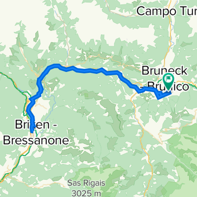
Von Bruneck mit der Kron-Gondel auf 2230m, dann immer dem 8er Weg folgend bis zur Asphaltstraße. Kurz wieder hoch zu den Pfaffenberger Höfen und dann über St. Vigil zur Pederü Hütte. Nun folgt noch ein anstrengender Anstieg rauf in die Fanes zur Lavarella Hütte.
- -:--
- Duration
- 41.2 km
- Distance
- 2,268 m
- Ascent
- 1,184 m
- Descent
- ---
- Avg. speed
- ---
- Max. altitude
Continue with Bikemap
Use, edit, or download this cycling route
You would like to ride Bruneck - Fanes / Lavarella or customize it for your own trip? Here is what you can do with this Bikemap route:
Free features
- Save this route as favorite or in collections
- Copy & plan your own version of this route
- Sync your route with Garmin or Wahoo
Premium features
Free trial for 3 days, or one-time payment. More about Bikemap Premium.
- Navigate this route on iOS & Android
- Export a GPX / KML file of this route
- Create your custom printout (try it for free)
- Download this route for offline navigation
Discover more Premium features.
Get Bikemap PremiumFrom our community
Other popular routes starting in Riscone
 Freeride - Kronplatz-Furcia
- Distance
- 4.5 km
- Ascent
- 0 m
- Descent
- 519 m
- Location
- Riscone, Trentino-Alto Adige, Italy
 Reischach - Brixen und zurück
- Distance
- 75.1 km
- Ascent
- 587 m
- Descent
- 589 m
- Location
- Riscone, Trentino-Alto Adige, Italy
 Schmetterlingsroute - Reischach - St.Sigmund - Hofern - Issing - Bruneck
- Distance
- 38.7 km
- Ascent
- 860 m
- Descent
- 857 m
- Location
- Riscone, Trentino-Alto Adige, Italy
 Schnelle Radrunde von Friedersreuth nach Olang kronplatz
- Distance
- 27.5 km
- Ascent
- 1,065 m
- Descent
- 661 m
- Location
- Riscone, Trentino-Alto Adige, Italy
 Bruneck - Fanes / Lavarella
- Distance
- 41.2 km
- Ascent
- 2,268 m
- Descent
- 1,184 m
- Location
- Riscone, Trentino-Alto Adige, Italy
 Reischach nach Weizgruber Alm
- Distance
- 33.1 km
- Ascent
- 1,451 m
- Descent
- 386 m
- Location
- Riscone, Trentino-Alto Adige, Italy
 Reischach - Bruneck -Reischach
- Distance
- 13.6 km
- Ascent
- 170 m
- Descent
- 173 m
- Location
- Riscone, Trentino-Alto Adige, Italy
 Kronplatz-Reischach
- Distance
- 28.1 km
- Ascent
- 145 m
- Descent
- 1,476 m
- Location
- Riscone, Trentino-Alto Adige, Italy
Open it in the app