

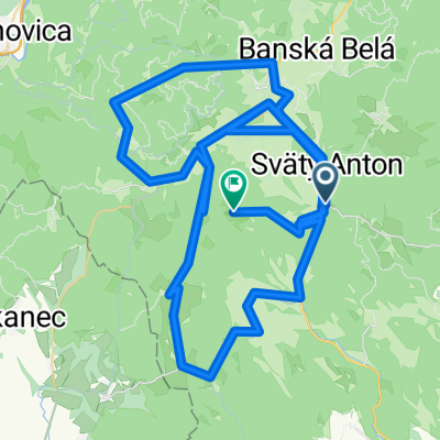
veľký hodrušský v daždi
A cycling route starting in Svätý Anton, Banská Bystrica Region, Slovakia.
Overview
About this route
- -:--
- Duration
- 53.5 km
- Distance
- 1,155 m
- Ascent
- 1,168 m
- Descent
- ---
- Avg. speed
- 826 m
- Max. altitude

Route photos

Route quality
Waytypes & surfaces along the route
Waytypes
Track
34.8 km
(65 %)
Road
10.7 km
(20 %)
Surfaces
Paved
10.2 km
(19 %)
Unpaved
28.9 km
(54 %)
Unpaved (undefined)
15 km
(28 %)
Asphalt
10.2 km
(19 %)
Continue with Bikemap
Use, edit, or download this cycling route
You would like to ride veľký hodrušský v daždi or customize it for your own trip? Here is what you can do with this Bikemap route:
Free features
- Save this route as favorite or in collections
- Copy & plan your own version of this route
- Sync your route with Garmin or Wahoo
Premium features
Free trial for 3 days, or one-time payment. More about Bikemap Premium.
- Navigate this route on iOS & Android
- Export a GPX / KML file of this route
- Create your custom printout (try it for free)
- Download this route for offline navigation
Discover more Premium features.
Get Bikemap PremiumFrom our community
Other popular routes starting in Svätý Anton
 Sitno extrem cesta
- Distance
- 147.2 km
- Ascent
- 2,606 m
- Descent
- 2,011 m
- Location
- Svätý Anton, Banská Bystrica Region, Slovakia
 Szczawnickie 1
- Distance
- 56.9 km
- Ascent
- 933 m
- Descent
- 934 m
- Location
- Svätý Anton, Banská Bystrica Region, Slovakia
 veľký hodrušský v daždi
- Distance
- 53.5 km
- Ascent
- 1,155 m
- Descent
- 1,168 m
- Location
- Svätý Anton, Banská Bystrica Region, Slovakia
 časovka do vrchu Sitno
- Distance
- 6.9 km
- Ascent
- 630 m
- Descent
- 40 m
- Location
- Svätý Anton, Banská Bystrica Region, Slovakia
 Barborská cesta 3. etapa
- Distance
- 42.1 km
- Ascent
- 1,208 m
- Descent
- 1,402 m
- Location
- Svätý Anton, Banská Bystrica Region, Slovakia
 Pocuvadlo-sitno
- Distance
- 10.4 km
- Ascent
- 379 m
- Descent
- 432 m
- Location
- Svätý Anton, Banská Bystrica Region, Slovakia
 ride from Banský Studenec to Štiavnické Bane
- Distance
- 14.1 km
- Ascent
- 576 m
- Descent
- 489 m
- Location
- Svätý Anton, Banská Bystrica Region, Slovakia
 2562, Žibritov do Nová 207
- Distance
- 9.6 km
- Ascent
- 76 m
- Descent
- 306 m
- Location
- Svätý Anton, Banská Bystrica Region, Slovakia
Open it in the app