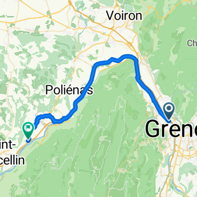
jour 1 : dans le Vercors
A cycling route starting in Fontaine, Auvergne-Rh么ne-Alpes, France.
Overview
About this route
voie de tram + route de la Moli猫re.
- -:--
- Duration
- 62.2 km
- Distance
- 1,948 m
- Ascent
- 1,117 m
- Descent
- ---
- Avg. speed
- 1,633 m
- Max. altitude
Route quality
Waytypes & surfaces along the route
Waytypes
Quiet road
26.3 km
(42 %)
Road
12.6 km
(20 %)
Surfaces
Paved
42.3 km
(68 %)
Unpaved
12.7 km
(20 %)
Asphalt
22.4 km
(36 %)
Paved (undefined)
19.9 km
(32 %)
Continue with Bikemap
Use, edit, or download this cycling route
You would like to ride jour 1 : dans le Vercors or customize it for your own trip? Here is what you can do with this Bikemap route:
Free features
- Save this route as favorite or in collections
- Copy & plan your own version of this route
- Sync your route with Garmin or Wahoo
Premium features
Free trial for 3 days, or one-time payment. More about Bikemap Premium.
- Navigate this route on iOS & Android
- Export a GPX / KML file of this route
- Create your custom printout (try it for free)
- Download this route for offline navigation
Discover more Premium features.
Get Bikemap PremiumFrom our community
Other popular routes starting in Fontaine
- Cr锚te de ma moli猫re
- Distance
- 87.3 km
- Ascent
- 1,801 m
- Descent
- 1,801 m
- Location
- Fontaine, Auvergne-Rh么ne-Alpes, France
- gravel aux vouillants
- Distance
- 16.3 km
- Ascent
- 337 m
- Descent
- 340 m
- Location
- Fontaine, Auvergne-Rh么ne-Alpes, France
- boucle en cartreuse
- Distance
- 39.4 km
- Ascent
- 826 m
- Descent
- 826 m
- Location
- Fontaine, Auvergne-Rh么ne-Alpes, France
- les chemins de traverse
- Distance
- 6.7 km
- Ascent
- 34 m
- Descent
- 40 m
- Location
- Fontaine, Auvergne-Rh么ne-Alpes, France
- Fontaine Saint Sim茅on de Br茅ssieux
- Distance
- 53.9 km
- Ascent
- 533 m
- Descent
- 361 m
- Location
- Fontaine, Auvergne-Rh么ne-Alpes, France
- petites roches
- Distance
- 53 km
- Ascent
- 1,004 m
- Descent
- 883 m
- Location
- Fontaine, Auvergne-Rh么ne-Alpes, France
- petites cotes au d茅part de fontaine
- Distance
- 36.4 km
- Ascent
- 665 m
- Descent
- 666 m
- Location
- Fontaine, Auvergne-Rh么ne-Alpes, France
- Grenoble 脿 Chemin de la Ch芒taigneraie, Vaulnaveys-le-Bas
- Distance
- 31.4 km
- Ascent
- 892 m
- Descent
- 759 m
- Location
- Fontaine, Auvergne-Rh么ne-Alpes, France
Open it in the app