
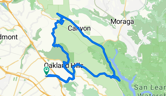
Moderately Strenuous Redwood Regional Loop
A cycling route starting in Piedmont, California, United States.
Overview
About this route
Strenuous climb up Redwood Road and Skyline in the beginning, followed by a slight downhill after Chabot Space and Science Center along Skyline Blvd (great views). A short, steep, technical drop starts when you get on Pinehurst, followed by a reasonably straigh, long downhill on the shady east side of Redwood Regional Park. A moderate climb to Skyline along Redwood Road from the East, before a steep decent down Redwood road.
- -:--
- Duration
- 27.1 km
- Distance
- 567 m
- Ascent
- 567 m
- Descent
- ---
- Avg. speed
- ---
- Max. altitude
Route quality
Waytypes & surfaces along the route
Waytypes
Road
3.8 km
(14 %)
Quiet road
0.8 km
(3 %)
Undefined
22.5 km
(83 %)
Surfaces
Paved
12.4 km
(46 %)
Asphalt
12.4 km
(46 %)
Undefined
14.6 km
(54 %)
Continue with Bikemap
Use, edit, or download this cycling route
You would like to ride Moderately Strenuous Redwood Regional Loop or customize it for your own trip? Here is what you can do with this Bikemap route:
Free features
- Save this route as favorite or in collections
- Copy & plan your own version of this route
- Sync your route with Garmin or Wahoo
Premium features
Free trial for 3 days, or one-time payment. More about Bikemap Premium.
- Navigate this route on iOS & Android
- Export a GPX / KML file of this route
- Create your custom printout (try it for free)
- Download this route for offline navigation
Discover more Premium features.
Get Bikemap PremiumFrom our community
Other popular routes starting in Piedmont
 Tunnel Road | Oakland, CA, USA
- Distance
- 4.6 km
- Ascent
- 406 m
- Descent
- 187 m
- Location
- Piedmont, California, United States
 grizzly to viks
- Distance
- 37.3 km
- Ascent
- 628 m
- Descent
- 626 m
- Location
- Piedmont, California, United States
 Redwood Heights / Montclair / Tunnel Rd / Skyline /Redwood Heights
- Distance
- 25.2 km
- Ascent
- 966 m
- Descent
- 926 m
- Location
- Piedmont, California, United States
 Moderately Strenuous Redwood Regional Loop
- Distance
- 27.1 km
- Ascent
- 567 m
- Descent
- 567 m
- Location
- Piedmont, California, United States
 Rockridge to Inspiration point
- Distance
- 32.5 km
- Ascent
- 718 m
- Descent
- 718 m
- Location
- Piedmont, California, United States
 Park - Snake - Skyline - Redwood - Pinehurst Loop
- Distance
- 38.2 km
- Ascent
- 720 m
- Descent
- 720 m
- Location
- Piedmont, California, United States
 Hill Bomb Redwood to Lake Merritt
- Distance
- 17.8 km
- Ascent
- 152 m
- Descent
- 541 m
- Location
- Piedmont, California, United States
 Over-the-Hills Loop
- Distance
- 44.3 km
- Ascent
- 723 m
- Descent
- 546 m
- Location
- Piedmont, California, United States
Open it in the app