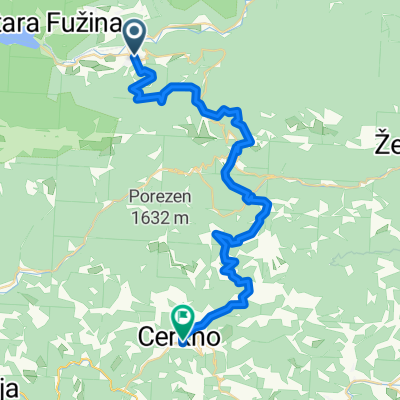
Stara Fužina - Planina Vogar - Stara Fužina
A cycling route starting in Bohinjska Bistrica, Bohinj, Slovenia.
Overview
About this route
- 4 h 2 min
- Duration
- 20.7 km
- Distance
- 819 m
- Ascent
- 826 m
- Descent
- 5.1 km/h
- Avg. speed
- 1,184 m
- Avg. speed
Route photos
Route quality
Waytypes & surfaces along the route
Waytypes
Undefined
20.7 km
(100 %)
Surfaces
Undefined
20.7 km
(100 %)
Continue with Bikemap
Use, edit, or download this cycling route
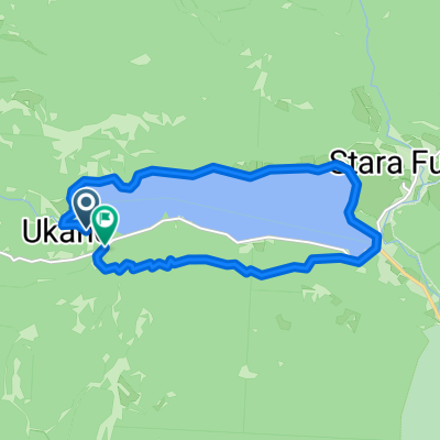
You would like to ride Stara Fužina - Planina Vogar - Stara Fužina or customize it for your own trip? Here is what you can do with this Bikemap route:
Free features
- Save this route as favorite or in collections
- Copy & plan your own version of this route
- Sync your route with Garmin or Wahoo
Premium features
Free trial for 3 days, or one-time payment. More about Bikemap Premium.
- Navigate this route on iOS & Android
- Export a GPX / KML file of this route
- Create your custom printout (try it for free)
- Download this route for offline navigation
Discover more Premium features.
Get Bikemap PremiumFrom our community
Other popular routes starting in Bohinjska Bistrica
- Bohinj-Nova Gorica
- Distance
- 105.8 km
- Ascent
- 4,715 m
- Descent
- 5,135 m
- Location
- Bohinjska Bistrica, Bohinj, Slovenia
- 2025. Bledi-tó-Ljubljana-Celje teljes
- Distance
- 173 km
- Ascent
- 2,965 m
- Descent
- 3,443 m
- Location
- Bohinjska Bistrica, Bohinj, Slovenia
- Zajamniki
- Distance
- 27 km
- Ascent
- 1,012 m
- Descent
- 1,014 m
- Location
- Bohinjska Bistrica, Bohinj, Slovenia
- Podbrdo-Nova Gorica
- Distance
- 68.5 km
- Ascent
- 2,632 m
- Descent
- 3,042 m
- Location
- Bohinjska Bistrica, Bohinj, Slovenia
- Day 2 Side Trip to Waterfall Savica
- Distance
- 7.8 km
- Ascent
- 239 m
- Descent
- 112 m
- Location
- Bohinjska Bistrica, Bohinj, Slovenia
- b.b- koprivnik-gorjuse-b.b
- Distance
- 46.6 km
- Ascent
- 888 m
- Descent
- 889 m
- Location
- Bohinjska Bistrica, Bohinj, Slovenia
- Along the Shady Hunter's Trail and the Sunny Northern Shore Around Lake Bohinj - Along the Shady Hunter's Trail and the Sunny Northern Shore Around Lake Bohinj
- Distance
- 16.1 km
- Ascent
- 409 m
- Descent
- 410 m
- Location
- Bohinjska Bistrica, Bohinj, Slovenia
- Day 2 Side Trip to Waterfall Savica
- Distance
- 15.6 km
- Ascent
- 337 m
- Descent
- 339 m
- Location
- Bohinjska Bistrica, Bohinj, Slovenia