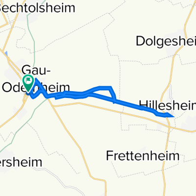
Route zum Warm werden
A cycling route starting in Gau-Odernheim, Rhineland-Palatinate, Germany.
Overview
About this route
- -:--
- Duration
- 221.6 km
- Distance
- 1,101 m
- Ascent
- 1,097 m
- Descent
- ---
- Avg. speed
- ---
- Avg. speed
Route highlights
Points of interest along the route
Point of interest after 109.1 km
Übernachtung in der Jugendherberge
Continue with Bikemap
Use, edit, or download this cycling route
You would like to ride Route zum Warm werden or customize it for your own trip? Here is what you can do with this Bikemap route:
Free features
- Save this route as favorite or in collections
- Copy & plan your own version of this route
- Sync your route with Garmin or Wahoo
Premium features
Free trial for 3 days, or one-time payment. More about Bikemap Premium.
- Navigate this route on iOS & Android
- Export a GPX / KML file of this route
- Create your custom printout (try it for free)
- Download this route for offline navigation
Discover more Premium features.
Get Bikemap PremiumFrom our community
Other popular routes starting in Gau-Odernheim
- 18km Rundkurs Gau-Odernh.-Schafhausen-Albig-Biebelnheim-Gau-Odernh.
- Distance
- 18.3 km
- Ascent
- 82 m
- Descent
- 79 m
- Location
- Gau-Odernheim, Rhineland-Palatinate, Germany
- Rund um den Petersberg 2011 - RTF des RV 1924 e.V. Gau-Odernheim - 111 km Strecke
- Distance
- 105.5 km
- Ascent
- 663 m
- Descent
- 663 m
- Location
- Gau-Odernheim, Rhineland-Palatinate, Germany
- Gau-Odernheim nach Alzey über Köngernheim
- Distance
- 9.7 km
- Ascent
- 55 m
- Descent
- 28 m
- Location
- Gau-Odernheim, Rhineland-Palatinate, Germany
- Gau-Odernheim_Alzey_Albig_Biebelnheim_Runde
- Distance
- 21.4 km
- Ascent
- 68 m
- Descent
- 67 m
- Location
- Gau-Odernheim, Rhineland-Palatinate, Germany
- Alzeyer Straße 39, Gau-Odernheim nach Hauptstraße 150, Alzey
- Distance
- 11.6 km
- Ascent
- 57 m
- Descent
- 9 m
- Location
- Gau-Odernheim, Rhineland-Palatinate, Germany
- Rund um den Petersberg 2011 - RTF des RV 1924 e.V. Gau-Odernheim - 45 km Strecke
- Distance
- 43.5 km
- Ascent
- 286 m
- Descent
- 286 m
- Location
- Gau-Odernheim, Rhineland-Palatinate, Germany
- Pusch-HQ
- Distance
- 28.8 km
- Ascent
- 160 m
- Descent
- 163 m
- Location
- Gau-Odernheim, Rhineland-Palatinate, Germany
- Route zum Warm werden
- Distance
- 221.6 km
- Ascent
- 1,101 m
- Descent
- 1,097 m
- Location
- Gau-Odernheim, Rhineland-Palatinate, Germany
Open it in the app