

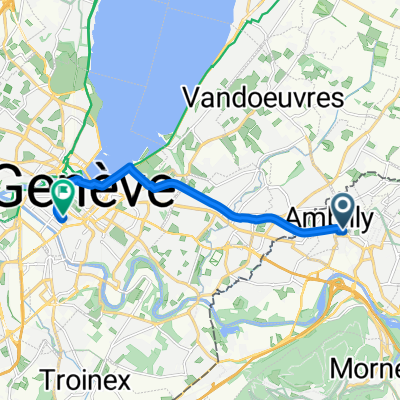
Rue Ernest Renan, Ambilly to Jonction, Geneva
- 8.7 km
- 24 m
- 75 m
- Annemasse, Auvergne-Rhône-Alpes, France
A cycling route starting in Annemasse, Auvergne-Rhône-Alpes, France.
Overview
This connecting route is interesting for touring cyclists coming down from Switzerland or Germany to go south, providing a discovery ride with return by train (including halfway, from Bons-en-Chablais or Machilly). Route direction: north/south. Landmarks and connections: Sciez (separation from the Circuit du Bas-Chablais n°31); Brens (crossing with the Tour des Voirons n°27 and the Circuit de la Vallée Verte n°28); Machilly (crossing with the Balcons d'Annemasse n°26). TER stations: Bons-en-Chablais, Machilly, Annemasse. Description: This route connecting the two major cities in the north of Haute Savoie is not without its merits: charming villages inland, forest passages, and views of Lake Machilly. The start is shared with the Circuit du Bas Chablais n°3, via the descent of the Avenue de Corzent. Upon reaching Anthy, head inland. In Sciez, you will find a new sharp left turn just before reaching the departmental road. This marks the beginning of a pleasant forest climb that takes you away from the coast and deep into Bas-Chablais. The final border section gently descends towards Ville-la-Grand and Annemasse. You may also choose to arrive in Sciez not via the inland route, but along the lake shores by continuing to follow the Circuit du Bas-Chablais after Anthy. In Sciez, you will carefully follow and then cross the departmental road 1005 to reconnect with the linking route. Discovery cycling route marked by the Department of Haute-Savoie as part of the Haute-Savoie Vélo Plan.
created this 3 years ago
Route quality
Road
23.4 km
(57 %)
Quiet road
11.9 km
(29 %)
Paved
34.4 km
(84 %)
Unpaved
2 km
(5 %)
Asphalt
34.4 km
(84 %)
Ground
0.8 km
(2 %)
Continue with Bikemap
You would like to ride 49 - Thonon / Annemasse or customize it for your own trip? Here is what you can do with this Bikemap route:
Free trial for 3 days, or one-time payment. More about Bikemap Premium.
Discover more Premium features.
Get Bikemap PremiumFrom our community
Open it in the app


