Route nach Am Ziegenberg, Kassel
- 124.7 km
- 1,027 m
- 1,338 m
- Clausthal-Zellerfeld, Lower Saxony, Germany
A cycling route starting in Clausthal-Zellerfeld, Lower Saxony, Germany.
Overview
Tour from Clausthal to Hanskühnenburg, then down via Stieglitzecke to the Okersteine, up to the Wolfswarte, down to the Steilen Wand, and after a somewhat laborious stretch with a lot of carrying, always along the dam ditch to the Dammhaus. From there, it's not far to the starting point.
A strenuous, but also very beautiful day tour that has everything an MTB enthusiast desires. Long climbs, steep downhills, beautiful views, and a nice ending for rolling out.
Start and finish in the parking lot on the B242 near the source of the Innerste.
created this 17 years ago
Route highlights
Noch vor der Brücke rechts abbiegen
Tiefster Punkt der Route, schöner Blick auf die Sösetalsperre. Ab jetzt geht es lange Zeit nur noch bergauf!
Hanskühneburg. Wunderschöne Aussichten, aber die Gaststätte ist ein wenig düster. Aber draußen sitzen ist toll :)
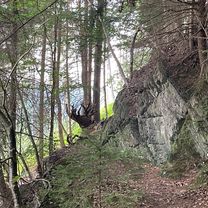
Hier kann man beruhigt die schräge Rampe hochfahren, obwohl es keine Schilder gibt. Irgendwann kommt man wieder auf den Hauptweg. Orientiert man sich dagegen nach rechts, kommt man zwar an tollen Felsen vorbei, hat aber eine fürchterliche Plackerei nach oben vor sich!
Hier geht ein kleiner Weg zur Wolfswarte hoch. Viele werden hier schieben müssen (ich auch ;). Aber es ist nicht weit.

Wolfwarte 918m, höchster Punkt der Tour. Ein fantastischer Rundblick über den Harz und den Brocken hat man direkt vor der Nase (siehe Bild).
Hier runter fahren macht nur Spaß, wenn man sein Bike wirklich gut beherrscht und keine Angst hat. Nach mehreren Regentagen nahezu unfahrbar!
Hier den Schildern nach Altenau folgen. Zuerst kommen etliche 100m, die nur für echte Freaks fahrbar sind. Otto Normalbiker muss hier immer wieder absteigen. Aber keine Panik, irgendwann ist auch das vorbei und dann wirds richtig schön.
Achtung: hier nicht dem breiten Schotterweg halb rechts folgen, sondern den kleineren Weg links runter zum Dammgraben nehmen.
Dammhaus: Hier kann man sich den wohlverdienten Cappucino reinziehen, bevor es an die letzten einfach Kilometer geht.
Continue with Bikemap
You would like to ride Oberharzer Aussichts- und Wassergrabentour or customize it for your own trip? Here is what you can do with this Bikemap route:
Free trial for 3 days, or one-time payment. More about Bikemap Premium.
Discover more Premium features.
Get Bikemap PremiumFrom our community
Open it in the app