

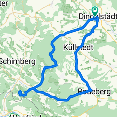
Dingelstädt-Heyerode-BadSooden
A cycling route starting in Dingelstädt, Thuringia, Germany.
Overview
About this route
Nutzt die Radwege "Unstrut","Unstrut-Werra"und "Werra". Alle genannten Radwege sind in sehr guten Zustand, führen durch landschaftlich schöne Regionen und sind gut ausgeschildert. Empfehlenswert ist eine Pause am alten Bahnhof Heyerode und am historischen Hafen in Wanfried.
- -:--
- Duration
- 91.5 km
- Distance
- 331 m
- Ascent
- 512 m
- Descent
- ---
- Avg. speed
- ---
- Max. altitude
Route quality
Waytypes & surfaces along the route
Waytypes
Track
23.5 km
(26 %)
Quiet road
22.2 km
(24 %)
Surfaces
Paved
63.7 km
(70 %)
Unpaved
14.9 km
(16 %)
Asphalt
55 km
(60 %)
Gravel
10.6 km
(12 %)
Continue with Bikemap
Use, edit, or download this cycling route
You would like to ride Dingelstädt-Heyerode-BadSooden or customize it for your own trip? Here is what you can do with this Bikemap route:
Free features
- Save this route as favorite or in collections
- Copy & plan your own version of this route
- Split it into stages to create a multi-day tour
- Sync your route with Garmin or Wahoo
Premium features
Free trial for 3 days, or one-time payment. More about Bikemap Premium.
- Navigate this route on iOS & Android
- Export a GPX / KML file of this route
- Create your custom printout (try it for free)
- Download this route for offline navigation
Discover more Premium features.
Get Bikemap PremiumFrom our community
Other popular routes starting in Dingelstädt
 Kanonenbahnradweg
- Distance
- 42.1 km
- Ascent
- 418 m
- Descent
- 419 m
- Location
- Dingelstädt, Thuringia, Germany
 Dingelstädt - Gleichenstein - Scharfenstein
- Distance
- 50.7 km
- Ascent
- 708 m
- Descent
- 708 m
- Location
- Dingelstädt, Thuringia, Germany
 1.Silberhausen Keffernhausen Unstrutquelle
- Distance
- 5.9 km
- Ascent
- 94 m
- Descent
- 53 m
- Location
- Dingelstädt, Thuringia, Germany
 Dingelstädt-Heyerode-BadSooden
- Distance
- 91.5 km
- Ascent
- 331 m
- Descent
- 512 m
- Location
- Dingelstädt, Thuringia, Germany
 Unstrut-Werra-Runde
- Distance
- 88.2 km
- Ascent
- 596 m
- Descent
- 596 m
- Location
- Dingelstädt, Thuringia, Germany
 Strecke Südeichsfeld
- Distance
- 48.2 km
- Ascent
- 788 m
- Descent
- 700 m
- Location
- Dingelstädt, Thuringia, Germany
 Runde zur Burg Hanstein
- Distance
- 79.2 km
- Ascent
- 1,037 m
- Descent
- 997 m
- Location
- Dingelstädt, Thuringia, Germany
 von Dingelstädt nach Kleinbartloff
- Distance
- 12.4 km
- Ascent
- 390 m
- Descent
- 449 m
- Location
- Dingelstädt, Thuringia, Germany
Open it in the app