
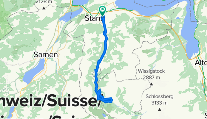
Stans-Oberdorf - Engelberg retour
A cycling route starting in Stans, Canton of Nidwalden, Switzerland.
Overview
About this route
Varied route with constant views of the Engelberger Aa. The Aa gorge with its 3 bridges is quite an experience!
- -:--
- Duration
- 43.4 km
- Distance
- 779 m
- Ascent
- 778 m
- Descent
- ---
- Avg. speed
- 1,036 m
- Max. altitude

Route quality
Waytypes & surfaces along the route
Waytypes
Track
26 km
(60 %)
Quiet road
8.7 km
(20 %)
Surfaces
Paved
20.8 km
(48 %)
Unpaved
16.9 km
(39 %)
Gravel
15.6 km
(36 %)
Paved (undefined)
11.7 km
(27 %)
Continue with Bikemap
Use, edit, or download this cycling route
You would like to ride Stans-Oberdorf - Engelberg retour or customize it for your own trip? Here is what you can do with this Bikemap route:
Free features
- Save this route as favorite or in collections
- Copy & plan your own version of this route
- Sync your route with Garmin or Wahoo
Premium features
Free trial for 3 days, or one-time payment. More about Bikemap Premium.
- Navigate this route on iOS & Android
- Export a GPX / KML file of this route
- Create your custom printout (try it for free)
- Download this route for offline navigation
Discover more Premium features.
Get Bikemap PremiumFrom our community
Other popular routes starting in Stans
 Cervelo Teststrecke
- Distance
- 108.7 km
- Ascent
- 360 m
- Descent
- 359 m
- Location
- Stans, Canton of Nidwalden, Switzerland
 Teil der Wettkampfstreck vom 12.9.10
- Distance
- 49.9 km
- Ascent
- 1,295 m
- Descent
- 1,295 m
- Location
- Stans, Canton of Nidwalden, Switzerland
 Stans-Bürgerstock-Stans
- Distance
- 24 km
- Ascent
- 581 m
- Descent
- 582 m
- Location
- Stans, Canton of Nidwalden, Switzerland
 Rütenen über Ennerberg
- Distance
- 29.6 km
- Ascent
- 418 m
- Descent
- 421 m
- Location
- Stans, Canton of Nidwalden, Switzerland
 Rosenweg 9, Stans nach Stansstaderstrasse 39
- Distance
- 29.6 km
- Ascent
- 273 m
- Descent
- 267 m
- Location
- Stans, Canton of Nidwalden, Switzerland
 Bürgenstock über Fürigen
- Distance
- 23.3 km
- Ascent
- 608 m
- Descent
- 610 m
- Location
- Stans, Canton of Nidwalden, Switzerland
 Stans, Alpgschwänd,Fräkmüntegg, Kriens, Stans
- Distance
- 41 km
- Ascent
- 2,465 m
- Descent
- 2,451 m
- Location
- Stans, Canton of Nidwalden, Switzerland
 St. Jakob über Rotzloch
- Distance
- 13.5 km
- Ascent
- 287 m
- Descent
- 285 m
- Location
- Stans, Canton of Nidwalden, Switzerland
Open it in the app