Kunžák-Nová Bystřice-Rakousko-Slavonice-Kunžák
- 74.6 km
- 854 m
- 837 m
- Kunžak, Jihočeský kraj, Czechia
A cycling route starting in Kunžak, Jihočeský kraj, Czechia.
Overview
21.7.2010
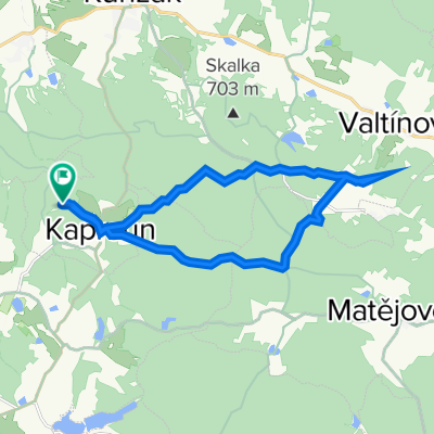
KAPROUN – KLENOVÁ - BLATO – KLÁŠTER – FILIPOV – NÁVARY – VECLOV - KUNÍ - TROJMEZÍ - MAŘÍŽ – PFAFFENSCHLAG - STÁLKOV – MATĚJOVEC - KAPROUN
Kaproun – on the road – Klenová – Blato – right – across fields – through forest – along Osika – Klášter – on route 1006 – through forest – Filipov – right – climbing through forest – forest path – descent to Návat – left on road – climb – descent – Veclov – crossroads 1007 – across fields – along border company – Kuní – left across fields – Větříš – climbing through forest – asphalt – Trojmezí – descent – Maříž – on route 1003 – road – left – on road – Strážný kopec – shortcut right – red trail – left through forest – border fortifications – descent through forest – stones – forest ponds – on red trail – Dědek near Slavonice – right – Pfaffenschlag – on road – left – on route 1004 – road – Stálkov – climb – Bukový vrch – route 1004 – Matějovec – around pond – through forest – road – Spáleniště – Rožnovská horka – around pond – Kaproun
created this 14 years ago
Route quality
Track
26.9 km
(59 %)
Road
11 km
(24 %)
Paved
20.5 km
(45 %)
Unpaved
13.2 km
(29 %)
Asphalt
19.2 km
(42 %)
Gravel
7.3 km
(16 %)
Continue with Bikemap
You would like to ride Kaproun 03 or customize it for your own trip? Here is what you can do with this Bikemap route:
Free trial for 3 days, or one-time payment. More about Bikemap Premium.
Discover more Premium features.
Get Bikemap PremiumFrom our community
Open it in the app