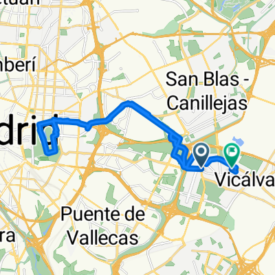
Vicálvaro-Anillo ciclista-El Pardo
A cycling route starting in Vicálvaro, Madrid, Spain.
Overview
About this route
Heading up the Avenida de la Estación in Vicálvaro and the Avenida de la Vicalvarada, you cross the M-40 and connect with the Madrid cycling ring via its bike lane, generally well signposted, until reaching the road to El Pardo-Fuencarral. We take the second path on the right that ascends and leads back to the road, and connect with the path that goes down to Somontes. There, we climb up to La Quinta and descend following the Arroyo Trocha down to El Pardo. We climb the Cristo and descend to start the return by taking the first path on the left that goes back to the road, and reconnect with the cycling ring back to Vicálvaro, the starting point.
- -:--
- Duration
- 68.3 km
- Distance
- 521 m
- Ascent
- 521 m
- Descent
- ---
- Avg. speed
- ---
- Max. altitude
Continue with Bikemap
Use, edit, or download this cycling route
You would like to ride Vicálvaro-Anillo ciclista-El Pardo or customize it for your own trip? Here is what you can do with this Bikemap route:
Free features
- Save this route as favorite or in collections
- Copy & plan your own version of this route
- Sync your route with Garmin or Wahoo
Premium features
Free trial for 3 days, or one-time payment. More about Bikemap Premium.
- Navigate this route on iOS & Android
- Export a GPX / KML file of this route
- Create your custom printout (try it for free)
- Download this route for offline navigation
Discover more Premium features.
Get Bikemap PremiumFrom our community
Other popular routes starting in Vicálvaro
- Vicálvaro - O'Donnell
- Distance
- 7.1 km
- Ascent
- 98 m
- Descent
- 113 m
- Location
- Vicálvaro, Madrid, Spain
- Calle de la Caliza, Madrid a Calle de Minerva, Madrid
- Distance
- 28.6 km
- Ascent
- 237 m
- Descent
- 235 m
- Location
- Vicálvaro, Madrid, Spain
- 20150321_Brevet_200_Vicalvaro
- Distance
- 204.9 km
- Ascent
- 824 m
- Descent
- 823 m
- Location
- Vicálvaro, Madrid, Spain
- Vicálvaro-Anillo ciclista-El Pardo
- Distance
- 68.3 km
- Ascent
- 521 m
- Descent
- 521 m
- Location
- Vicálvaro, Madrid, Spain
- 21 sep
- Distance
- 86.9 km
- Ascent
- 627 m
- Descent
- 622 m
- Location
- Vicálvaro, Madrid, Spain
- Anillo Verde (Vicálvaro) - Parque lineal (Rivas)
- Distance
- 29 km
- Ascent
- 173 m
- Descent
- 245 m
- Location
- Vicálvaro, Madrid, Spain
- Vicalvaro - Cortados de Rivas
- Distance
- 36.6 km
- Ascent
- 230 m
- Descent
- 244 m
- Location
- Vicálvaro, Madrid, Spain
- Morata - Tielmes - Carabaña - Orusco - Valdilecha
- Distance
- 112.7 km
- Ascent
- 658 m
- Descent
- 658 m
- Location
- Vicálvaro, Madrid, Spain
Open it in the app