

OSKIS_Ortoto_route_Part3
A cycling route starting in Saint Vlas, Burgas, Bulgaria.
Overview
About this route
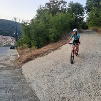
Combination of road trip and off-road, downhill bicycle tripOSKIS recommendations:- the road condition on mountains is quite complicated for cycling: 1st part with high climbing grade (from 20%) and full of rocks (slippery)- it needs a good level of bicycling experience and special equipment, like gloves, helmet, bag and enduro/downhill bike as well- use this route for bike tour w/ guide- usually it takes 3-4hrs for the whole trip- no shops or cafes over there, that's why it necessary to take with you: bottles of water, energy bars..- don't recommend to use it after the rain or on standard mountain bikes - the road condition will be very complicated on mountains: mostly climbing uphill w/ or on bike, during downhill - a lot of drops, stones on the ground and different turns, plus high speed (avr.: 12,5km/h, top: from 48km/h)
- -:--
- Duration
- 19.2 km
- Distance
- 509 m
- Ascent
- 483 m
- Descent
- ---
- Avg. speed
- 387 m
- Max. altitude
Route quality
Waytypes & surfaces along the route
Waytypes
Track
8.9 km
(47 %)
Quiet road
4.5 km
(23 %)
Surfaces
Paved
2.3 km
(12 %)
Unpaved
4.4 km
(23 %)
Gravel
4 km
(21 %)
Asphalt
1.9 km
(10 %)
Continue with Bikemap
Use, edit, or download this cycling route
You would like to ride OSKIS_Ortoto_route_Part3 or customize it for your own trip? Here is what you can do with this Bikemap route:
Free features
- Save this route as favorite or in collections
- Copy & plan your own version of this route
- Sync your route with Garmin or Wahoo
Premium features
Free trial for 3 days, or one-time payment. More about Bikemap Premium.
- Navigate this route on iOS & Android
- Export a GPX / KML file of this route
- Create your custom printout (try it for free)
- Download this route for offline navigation
Discover more Premium features.
Get Bikemap PremiumFrom our community
Other popular routes starting in Saint Vlas
 Irakli
- Distance
- 13.1 km
- Ascent
- 387 m
- Descent
- 463 m
- Location
- Saint Vlas, Burgas, Bulgaria
 Пat bez ime, Sveti Vlas to Пat bez ime, Sveti Vlas
- Distance
- 24.8 km
- Ascent
- 617 m
- Descent
- 574 m
- Location
- Saint Vlas, Burgas, Bulgaria
 "Black Sea Route" Epic Tour 2025 - Day 7-Emona-Sarafovo
- Distance
- 61.6 km
- Ascent
- 523 m
- Descent
- 672 m
- Location
- Saint Vlas, Burgas, Bulgaria
 elenite
- Distance
- 16.4 km
- Ascent
- 545 m
- Descent
- 539 m
- Location
- Saint Vlas, Burgas, Bulgaria
 Nessebar2010
- Distance
- 38 km
- Ascent
- 737 m
- Descent
- 737 m
- Location
- Saint Vlas, Burgas, Bulgaria
 Brevet week Nobel 2013_1000 km.
- Distance
- 1,000.9 km
- Ascent
- 2,911 m
- Descent
- 2,911 m
- Location
- Saint Vlas, Burgas, Bulgaria
 kula
kula- Distance
- 6.6 km
- Ascent
- 401 m
- Descent
- 11 m
- Location
- Saint Vlas, Burgas, Bulgaria
 OSKIS_Ortoto_route_Part3
- Distance
- 19.2 km
- Ascent
- 509 m
- Descent
- 483 m
- Location
- Saint Vlas, Burgas, Bulgaria
Open it in the app