Schloß und Brauerei Fallersleben
- 61.2 km
- 318 m
- 319 m
- Braunschweig, Lower Saxony, Germany
A cycling route starting in Braunschweig, Lower Saxony, Germany.
Overview
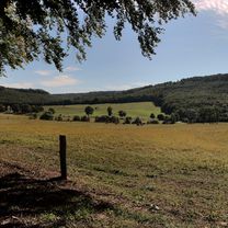
The way to Fallersleben leads through beautiful forest areas with many interesting informational signs about the plant and animal life.
You will also come across a few lesser-known things, like the 'Brunswick Primeval Forest' and the former Ehmen swimming baths from 1938.
At the destination, a historic brewery inn and Schloss Fallersleben await you. The old town of Fallersleben is also worth seeing.
The return journey initially goes to the large ship lock on the canal and over the long railway bridge.
Continue to the mouth of the Elbe side canal. Then continue along the Mittelland canal up to Brunswick.
created this 3 years ago


Route quality
Track
20.8 km
34 %
Path
13.5 km
22 %
Paved
22.6 km
(37 %)
Unpaved
29.4 km
(48 %)
Asphalt
20.2 km
33 %
Gravel
13.5 km
22 %
Continue with Bikemap
You would like to ride Schloß und Brauerei Fallersleben or customize it for your own trip? Here is what you can do with this Bikemap route:
Free trial for 3 days, or one-time payment. More about Bikemap Premium.
Discover more Premium features.
Get Bikemap PremiumFrom our community
Open it in the app