Léon -- Phare Pt St.Martin73km 270mu, 270md
A cycling route starting in Léon, Nouvelle-Aquitaine, France.
Overview
About this route
About 1/2 way along the coast, the rest through the forest, lighthouse at the end about 70 km before Biarritz
- -:--
- Duration
- 72.7 km
- Distance
- 411 m
- Ascent
- 400 m
- Descent
- ---
- Avg. speed
- 46 m
- Max. altitude
Route quality
Waytypes & surfaces along the route
Waytypes
Cycleway
42.2 km
(58 %)
Path
14.5 km
(20 %)
Surfaces
Paved
59.6 km
(82 %)
Unpaved
0.7 km
(1 %)
Asphalt
58.2 km
(80 %)
Concrete
1.5 km
(2 %)
Continue with Bikemap
Use, edit, or download this cycling route
You would like to ride Léon -- Phare Pt St.Martin73km 270mu, 270md or customize it for your own trip? Here is what you can do with this Bikemap route:
Free features
- Save this route as favorite or in collections
- Copy & plan your own version of this route
- Sync your route with Garmin or Wahoo
Premium features
Free trial for 3 days, or one-time payment. More about Bikemap Premium.
- Navigate this route on iOS & Android
- Export a GPX / KML file of this route
- Create your custom printout (try it for free)
- Download this route for offline navigation
Discover more Premium features.
Get Bikemap PremiumFrom our community
Other popular routes starting in Léon
- Léon -- Phare Pt St.Martin73km 270mu, 270md
- Distance
- 72.7 km
- Ascent
- 411 m
- Descent
- 400 m
- Location
- Léon, Nouvelle-Aquitaine, France
- 1988 - Tour de France - 05. Tag - Léon - Mézin
- Distance
- 154 km
- Ascent
- 690 m
- Descent
- 586 m
- Location
- Léon, Nouvelle-Aquitaine, France
- Chemin du Menoy 93, Léon nach Rue de la Douane 11, Mimizan
- Distance
- 57.9 km
- Ascent
- 124 m
- Descent
- 186 m
- Location
- Léon, Nouvelle-Aquitaine, France
- 34 - Léon / Capbreton
- Distance
- 33.3 km
- Ascent
- 252 m
- Descent
- 270 m
- Location
- Léon, Nouvelle-Aquitaine, France
- Easy Mardi Track In Vielle-Saint-Girons
- Distance
- 13.1 km
- Ascent
- 225 m
- Descent
- 211 m
- Location
- Léon, Nouvelle-Aquitaine, France
- De Moliets-et-Maa à Moliets-et-Maa
- Distance
- 13.1 km
- Ascent
- 89 m
- Descent
- 89 m
- Location
- Léon, Nouvelle-Aquitaine, France
- moliets / biarritz
- Distance
- 55.1 km
- Ascent
- 116 m
- Descent
- 100 m
- Location
- Léon, Nouvelle-Aquitaine, France
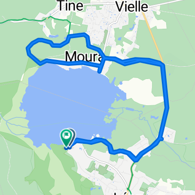
- Route von Chemin du Menoy 33, Léon nach Mimizan Plage
- Distance
- 48.4 km
- Ascent
- 293 m
- Descent
- 301 m
- Location
- Léon, Nouvelle-Aquitaine, France
Open it in the app