
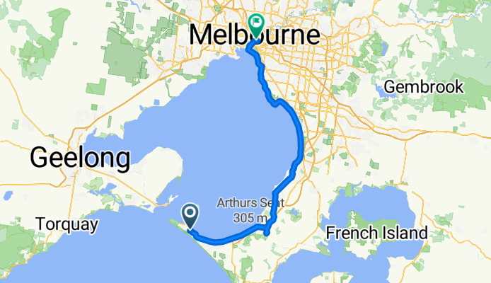
Round The Bay 2011
A cycling route starting in Sorrento, Victoria, Australia.
Overview
About this route
Start at Sorrento Ocean Beach Road, head to Point Nepean Road, veer right before you reach Marine Parade<br />towards Nepean Highway, The Briars and Olivers Hill on Nepean Highway single file as the<br />road narrows, take Nepean Highway all the way through to Beach Road Mordialloc, Peter<br />Scullin Reserve, St Kilda Street, Ormond<br />Esplanade, Beaconsfield Parade, right hand hook turn from Beaconsfield Parade into Pickle Street, right hand hook turn from Ingles Street into Crockford Street, City Road, Alexandra Avenue, Boathouse Drive, and Alexandra Gardens Finish.
- -:--
- Duration
- 111.1 km
- Distance
- 307 m
- Ascent
- 326 m
- Descent
- ---
- Avg. speed
- ---
- Max. altitude
Continue with Bikemap
Use, edit, or download this cycling route
You would like to ride Round The Bay 2011 or customize it for your own trip? Here is what you can do with this Bikemap route:
Free features
- Save this route as favorite or in collections
- Copy & plan your own version of this route
- Split it into stages to create a multi-day tour
- Sync your route with Garmin or Wahoo
Premium features
Free trial for 3 days, or one-time payment. More about Bikemap Premium.
- Navigate this route on iOS & Android
- Export a GPX / KML file of this route
- Create your custom printout (try it for free)
- Download this route for offline navigation
Discover more Premium features.
Get Bikemap PremiumFrom our community
Other popular routes starting in Sorrento
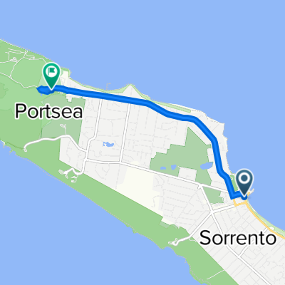
 Defence Road, Portsea to Defence Road, Portsea
- Distance
- 15.7 km
- Ascent
- 181 m
- Descent
- 166 m
- Location
- Sorrento, Victoria, Australia
 Danson Drive, Portsea to Coles Track, Portsea
- Distance
- 1.9 km
- Ascent
- 0 m
- Descent
- 0 m
- Location
- Sorrento, Victoria, Australia
 Queenscliff to St Kilda
- Distance
- 98.8 km
- Ascent
- 263 m
- Descent
- 262 m
- Location
- Sorrento, Victoria, Australia
 Blairgowie Portsea Road
- Distance
- 33.3 km
- Ascent
- 189 m
- Descent
- 189 m
- Location
- Sorrento, Victoria, Australia
 Danson Drive, Portsea to Danson Drive, Portsea
- Distance
- 12.4 km
- Ascent
- 0 m
- Descent
- 3 m
- Location
- Sorrento, Victoria, Australia
 1–7 The Esplanade, Sorrento to Defence Rd, Portsea
- Distance
- 5.3 km
- Ascent
- 69 m
- Descent
- 52 m
- Location
- Sorrento, Victoria, Australia
 4 Seabird Way, Portsea to 10 Clifton Street, Prahran
- Distance
- 97.4 km
- Ascent
- 18 m
- Descent
- 33 m
- Location
- Sorrento, Victoria, Australia
 RTB Sorrento-Albert Park
- Distance
- 99.5 km
- Ascent
- 506 m
- Descent
- 493 m
- Location
- Sorrento, Victoria, Australia
Open it in the app