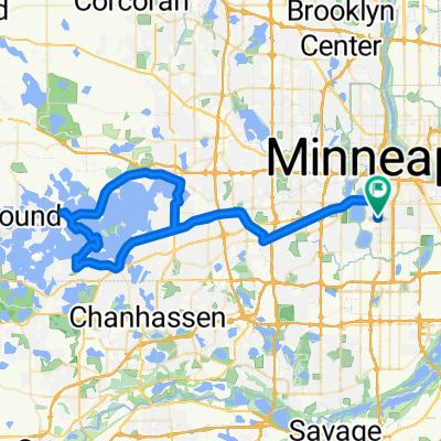
- 76.9 km
- 453 m
- 452 m
- Saint Louis Park, Minnesota, United States
Possible bike tour
A cycling route starting in Saint Louis Park, Minnesota, United States.
Overview
About this route
This is a bike tour i'm going to do in the end of May. I may not ride after new ulm because I need to move out of my apartment by the end of May.
- -:--
- Duration
- 880.9 km
- Distance
- 1,461 m
- Ascent
- 1,448 m
- Descent
- ---
- Avg. speed
- 482 m
- Max. altitude
created this 16 years ago
Route quality
Waytypes & surfaces along the route
Waytypes
Road
343.6 km
(39 %)
Quiet road
264.3 km
(30 %)
Surfaces
Paved
308.3 km
(35 %)
Unpaved
132.1 km
(15 %)
Asphalt
273.1 km
(31 %)
Gravel
105.7 km
(12 %)
Route highlights
Points of interest along the route
Point of interest after 156.6 km
Point of interest after 156.9 km
Camping at Minneopa state park. 90ish mile day
Point of interest after 157.1 km
Point of interest after 307.9 km
Camping at Mound Creek Campground. 507.648.3618 90ish mile day
Point of interest after 411.3 km
3rd nights stay in Camden State Park. 60ish mile day
Point of interest after 578.6 km
4th nights stay at Upper Sioux Agency campground. 90ish mile day
Point of interest after 706.4 km
Final Camping at Flandrau State Park. 90ish mile day
Continue with Bikemap
Use, edit, or download this cycling route
You would like to ride Possible bike tour or customize it for your own trip? Here is what you can do with this Bikemap route:
Free features
- Save this route as favorite or in collections
- Copy & plan your own version of this route
- Split it into stages to create a multi-day tour
- Sync your route with Garmin or Wahoo
Premium features
Free trial for 3 days, or one-time payment. More about Bikemap Premium.
- Navigate this route on iOS & Android
- Export a GPX / KML file of this route
- Create your custom printout (try it for free)
- Download this route for offline navigation
Discover more Premium features.
Get Bikemap PremiumFrom our community
Other popular routes starting in Saint Louis Park
- Fletcher's 50
- Meadow Ln S, Golden Valley to Tonka Bay Rd, Tonka Bay
- 32.4 km
- 130 m
- 110 m
- Saint Louis Park, Minnesota, United States
- B2B00041 55416 > 55114 via Greenway and Pelham
- 14.3 km
- 48 m
- 51 m
- Saint Louis Park, Minnesota, United States
- Midtown Greenway, Minneapolis to Hennepin Ave, Minneapolis
- 3.9 km
- 32 m
- 32 m
- Saint Louis Park, Minnesota, United States
- Glencrest Rd, Golden Valley to Thomas Ave N, Minneapolis
- 3.5 km
- 29 m
- 43 m
- Saint Louis Park, Minnesota, United States
- S. Mpls Loop 36k
- 36.2 km
- 175 m
- 197 m
- Saint Louis Park, Minnesota, United States
- round mtka
- 65 km
- 158 m
- 159 m
- Saint Louis Park, Minnesota, United States
- SJB Ride 20150515
- 34.1 km
- 97 m
- 99 m
- Saint Louis Park, Minnesota, United States
Open it in the app


