

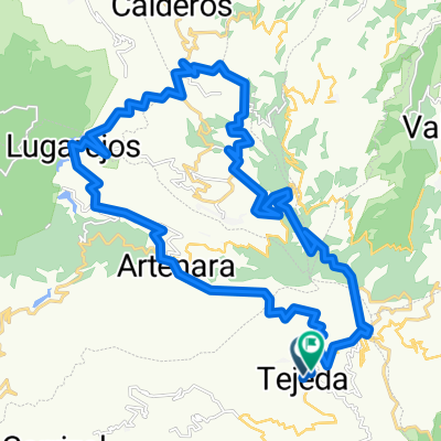
Gran Canaria Topround
A cycling route starting in Tejeda, Canary Islands, Spain.
Overview
About this route
- -:--
- Duration
- 34.1 km
- Distance
- 2,069 m
- Ascent
- 2,038 m
- Descent
- ---
- Avg. speed
- 1,753 m
- Max. altitude
Route quality
Waytypes & surfaces along the route
Waytypes
Road
5.1 km
(15 %)
Path
0.7 km
(2 %)
Undefined
28.3 km
(83 %)
Surfaces
Paved
33.4 km
(98 %)
Unpaved
0.7 km
(2 %)
Asphalt
33.4 km
(98 %)
Ground
0.7 km
(2 %)
Continue with Bikemap
Use, edit, or download this cycling route
You would like to ride Gran Canaria Topround or customize it for your own trip? Here is what you can do with this Bikemap route:
Free features
- Save this route as favorite or in collections
- Copy & plan your own version of this route
- Sync your route with Garmin or Wahoo
Premium features
Free trial for 3 days, or one-time payment. More about Bikemap Premium.
- Navigate this route on iOS & Android
- Export a GPX / KML file of this route
- Create your custom printout (try it for free)
- Download this route for offline navigation
Discover more Premium features.
Get Bikemap PremiumFrom our community
Other popular routes starting in Tejeda
 Rund um den Roque Nublo
- Distance
- 42.9 km
- Ascent
- 1,348 m
- Descent
- 1,107 m
- Location
- Tejeda, Canary Islands, Spain
 Tejeda around
- Distance
- 40.5 km
- Ascent
- 1,128 m
- Descent
- 1,075 m
- Location
- Tejeda, Canary Islands, Spain
 - Montañón Negro - El Risco de San Nicolás
- Distance
- 37.5 km
- Ascent
- 503 m
- Descent
- 2,045 m
- Location
- Tejeda, Canary Islands, Spain
 Gran Canaria Topround
- Distance
- 34.1 km
- Ascent
- 2,069 m
- Descent
- 2,038 m
- Location
- Tejeda, Canary Islands, Spain
 GC 007: Malerische Runde über La Culata
- Distance
- 10.4 km
- Ascent
- 561 m
- Descent
- 562 m
- Location
- Tejeda, Canary Islands, Spain
 GC 002: Im Naturreservat Pajonales
- Distance
- 13.8 km
- Ascent
- 402 m
- Descent
- 401 m
- Location
- Tejeda, Canary Islands, Spain
 GC07_87_1900
- Distance
- 87 km
- Ascent
- 1,593 m
- Descent
- 1,593 m
- Location
- Tejeda, Canary Islands, Spain
 centro isla
- Distance
- 79.7 km
- Ascent
- 1,854 m
- Descent
- 1,809 m
- Location
- Tejeda, Canary Islands, Spain
Open it in the app