

Grosse Acht (67Km)
A cycling route starting in Landkern, Rhineland-Palatinate, Germany.
Overview
About this route
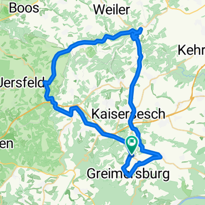
From the parking lot, we go to Laubach and down to Lirstal. Through Retterath and Mannebach, Mosbruch to Ulmen. Once around the pond. Then towards Kelberg and Uersfeld along the valley to Monreal. A great rest opportunity is the Stellwerk in Monreal (just before turning right up to Kaiseresch). Back to the parking lot via Kaiseresch. Unfortunately, the last stretch is quite busy.
- -:--
- Duration
- 67.2 km
- Distance
- 641 m
- Ascent
- 712 m
- Descent
- ---
- Avg. speed
- 570 m
- Max. altitude

Route quality
Waytypes & surfaces along the route
Waytypes
Road
14.1 km
(21 %)
Track
10.8 km
(16 %)
Surfaces
Paved
54.4 km
(81 %)
Unpaved
3.4 km
(5 %)
Asphalt
54.4 km
(81 %)
Ground
2 km
(3 %)
Continue with Bikemap
Use, edit, or download this cycling route
You would like to ride Grosse Acht (67Km) or customize it for your own trip? Here is what you can do with this Bikemap route:
Free features
- Save this route as favorite or in collections
- Copy & plan your own version of this route
- Sync your route with Garmin or Wahoo
Premium features
Free trial for 3 days, or one-time payment. More about Bikemap Premium.
- Navigate this route on iOS & Android
- Export a GPX / KML file of this route
- Create your custom printout (try it for free)
- Download this route for offline navigation
Discover more Premium features.
Get Bikemap PremiumFrom our community
Other popular routes starting in Landkern
 Kleine Runde (44Km)
- Distance
- 43.6 km
- Ascent
- 618 m
- Descent
- 649 m
- Location
- Landkern, Rhineland-Palatinate, Germany
 Mosel-Hunsrück-Eifel Mix (103Km)
- Distance
- 103 km
- Ascent
- 1,056 m
- Descent
- 1,056 m
- Location
- Landkern, Rhineland-Palatinate, Germany
 Alter Post weg nach Cochem
- Distance
- 17.7 km
- Ascent
- 407 m
- Descent
- 407 m
- Location
- Landkern, Rhineland-Palatinate, Germany
 Hauptstraße 74, Landkern nach Koblenzer Straße 1B, Kaisersesch
- Distance
- 7.5 km
- Ascent
- 150 m
- Descent
- 137 m
- Location
- Landkern, Rhineland-Palatinate, Germany
 Mosel - und Eifelmix 2 (86Km)
- Distance
- 86.4 km
- Ascent
- 824 m
- Descent
- 825 m
- Location
- Landkern, Rhineland-Palatinate, Germany
 Mosel - und Eifelmix (70Km)
- Distance
- 69.6 km
- Ascent
- 739 m
- Descent
- 737 m
- Location
- Landkern, Rhineland-Palatinate, Germany
 4 - Landkern - Guldental
- Distance
- 102.6 km
- Ascent
- 517 m
- Descent
- 778 m
- Location
- Landkern, Rhineland-Palatinate, Germany
 Riesen Eifelrundfahrt (177Km)
- Distance
- 177.4 km
- Ascent
- 820 m
- Descent
- 822 m
- Location
- Landkern, Rhineland-Palatinate, Germany
Open it in the app