

A(z) Bp Országúti kerékpározás kezdete - A(z) Bp Országúti kerékpározás vége - Bp Országúti kerékpározás
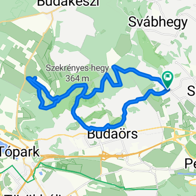
A cycling route starting in Budaörs, Pest County, Hungary.
Overview
About this route
July 7, 2022, 9:14 CEST Elevation: 123 m - July 7, 2022, 15:50 CEST Elevation: 120 m - The statistics were calculated by the system based on imported data July 7, 2022, 9:14 CEST Distance: 59.9 km Duration: 6 hours, 36 minutes and 22 seconds Average speed: 9.1 km/h Minimum elevation: 106 m Maximum elevation: 254 m Total ascent: 508 m Total descent: 510 m
- -:--
- Duration
- 62.3 km
- Distance
- 555 m
- Ascent
- 572 m
- Descent
- ---
- Avg. speed
- 258 m
- Max. altitude

Route quality
Waytypes & surfaces along the route
Waytypes
Quiet road
35.5 km
(57 %)
Cycleway
13.7 km
(22 %)
Surfaces
Paved
52.3 km
(84 %)
Unpaved
0.6 km
(1 %)
Asphalt
51.7 km
(83 %)
Paved (undefined)
0.6 km
(1 %)
Continue with Bikemap
Use, edit, or download this cycling route
You would like to ride A(z) Bp Országúti kerékpározás kezdete - A(z) Bp Országúti kerékpározás vége - Bp Országúti kerékpározás or customize it for your own trip? Here is what you can do with this Bikemap route:
Free features
- Save this route as favorite or in collections
- Copy & plan your own version of this route
- Sync your route with Garmin or Wahoo
Premium features
Free trial for 3 days, or one-time payment. More about Bikemap Premium.
- Navigate this route on iOS & Android
- Export a GPX / KML file of this route
- Create your custom printout (try it for free)
- Download this route for offline navigation
Discover more Premium features.
Get Bikemap PremiumFrom our community
Other popular routes starting in Budaörs
 hajtás csere utáni teszt kör
- Distance
- 44.4 km
- Ascent
- 559 m
- Descent
- 541 m
- Location
- Budaörs, Pest County, Hungary
 Hajtás (kis)Pajtás
- Distance
- 22.6 km
- Ascent
- 401 m
- Descent
- 400 m
- Location
- Budaörs, Pest County, Hungary
 Budai Tajvedelmi Körzet
- Distance
- 20.5 km
- Ascent
- 543 m
- Descent
- 544 m
- Location
- Budaörs, Pest County, Hungary
 Budai variáció
- Distance
- 29.1 km
- Ascent
- 858 m
- Descent
- 861 m
- Location
- Budaörs, Pest County, Hungary
 Kolozsvári utca, Budaörs nach Kolozsvári utca, Budaörs
- Distance
- 47.2 km
- Ascent
- 405 m
- Descent
- 408 m
- Location
- Budaörs, Pest County, Hungary
 Mária út M02-Czestochowa-Budapest-Međugorje, Будапешт до Mária út M02-Czestochowa-Budapest-Međugorje, Будапешт
- Distance
- 11.4 km
- Ascent
- 428 m
- Descent
- 429 m
- Location
- Budaörs, Pest County, Hungary
 CBA - Velence
- Distance
- 58.1 km
- Ascent
- 545 m
- Descent
- 565 m
- Location
- Budaörs, Pest County, Hungary
 2016-04-30_10-23-00_Sorrento_Lechner
- Distance
- 6 km
- Ascent
- 201 m
- Descent
- 201 m
- Location
- Budaörs, Pest County, Hungary
Open it in the app