

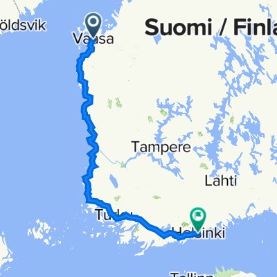
Handelsesplanaden 13, Vasa to Mannerheimvägen 22, Helsingfors
A cycling route starting in Vaasa, Ostrobothnia, Finland.
Overview
About this route
- 36 h 32 min
- Duration
- 607 km
- Distance
- 3,054 m
- Ascent
- 3,034 m
- Descent
- 16.6 km/h
- Avg. speed
- 102 m
- Max. altitude

Route quality
Waytypes & surfaces along the route
Waytypes
Road
212.4 km
(35 %)
Cycleway
151.7 km
(25 %)
Surfaces
Paved
424.9 km
(70 %)
Unpaved
30.3 km
(5 %)
Asphalt
346 km
(57 %)
Paved (undefined)
78.9 km
(13 %)
Continue with Bikemap
Use, edit, or download this cycling route
You would like to ride Handelsesplanaden 13, Vasa to Mannerheimvägen 22, Helsingfors or customize it for your own trip? Here is what you can do with this Bikemap route:
Free features
- Save this route as favorite or in collections
- Copy & plan your own version of this route
- Split it into stages to create a multi-day tour
- Sync your route with Garmin or Wahoo
Premium features
Free trial for 3 days, or one-time payment. More about Bikemap Premium.
- Navigate this route on iOS & Android
- Export a GPX / KML file of this route
- Create your custom printout (try it for free)
- Download this route for offline navigation
Discover more Premium features.
Get Bikemap PremiumFrom our community
Other popular routes starting in Vaasa
 52 tappa Bergamo-Nordkapp
- Distance
- 111.3 km
- Ascent
- 148 m
- Descent
- 147 m
- Location
- Vaasa, Ostrobothnia, Finland
 Handelsesplanaden 13, Vasa to Mannerheimvägen 22, Helsingfors
- Distance
- 607 km
- Ascent
- 3,054 m
- Descent
- 3,034 m
- Location
- Vaasa, Ostrobothnia, Finland
 nationell cykel vasa
- Distance
- 98.9 km
- Ascent
- 83 m
- Descent
- 82 m
- Location
- Vaasa, Ostrobothnia, Finland
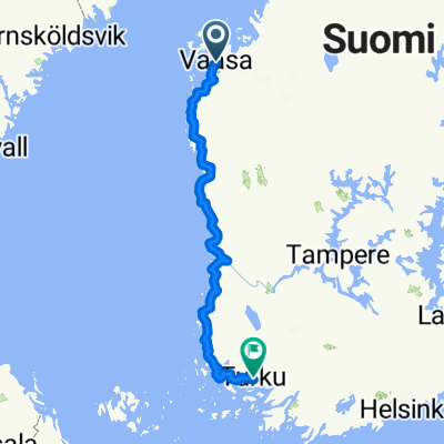
 01: Vaasa– Turku (Developed)
- Distance
- 544.2 km
- Ascent
- 717 m
- Descent
- 721 m
- Location
- Vaasa, Ostrobothnia, Finland
 От Raastuvankatu 26, Vaasa до Hertig Johans parkgata 8, Åbo
- Distance
- 592.7 km
- Ascent
- 1,634 m
- Descent
- 1,633 m
- Location
- Vaasa, Ostrobothnia, Finland
 Meijerinkatu 8, Vaasa naar Rådhusgatan 2, Pietarsaari
- Distance
- 134.1 km
- Ascent
- 426 m
- Descent
- 423 m
- Location
- Vaasa, Ostrobothnia, Finland
 Vasa-Turku
- Distance
- 467.2 km
- Ascent
- 135 m
- Descent
- 123 m
- Location
- Vaasa, Ostrobothnia, Finland
 Vaasa Cycling
- Distance
- 31.6 km
- Ascent
- 108 m
- Descent
- 81 m
- Location
- Vaasa, Ostrobothnia, Finland
Open it in the app