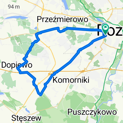
Zosi i Marysi trasa2
A cycling route starting in Pozna艅, Greater Poland Voivodeship, Poland.
Overview
About this route
-
Szamotu艂y 33
-
Sierak贸w 76 (43)
-
Pszczew 110 (34)
-
Lubniewice 154 (44)
-
O艣no Lubuskie 190 (36)
- -:--
- Duration
- 221.4 km
- Distance
- 1,231 m
- Ascent
- 1,294 m
- Descent
- ---
- Avg. speed
- 148 m
- Avg. speed
Route quality
Waytypes & surfaces along the route
Waytypes
Road
89.2 km
(40 %)
Busy road
49.3 km
(22 %)
Surfaces
Paved
159.4 km
(72 %)
Unpaved
15.3 km
(7 %)
Asphalt
141.8 km
(64 %)
Paving stones
10.4 km
(5 %)
Continue with Bikemap
Use, edit, or download this cycling route
You would like to ride Zosi i Marysi trasa2 or customize it for your own trip? Here is what you can do with this Bikemap route:
Free features
- Save this route as favorite or in collections
- Copy & plan your own version of this route
- Sync your route with Garmin or Wahoo
Premium features
Free trial for 3 days, or one-time payment. More about Bikemap Premium.
- Navigate this route on iOS & Android
- Export a GPX / KML file of this route
- Create your custom printout (try it for free)
- Download this route for offline navigation
Discover more Premium features.
Get Bikemap PremiumFrom our community
Other popular routes starting in Pozna艅
- Ogrody ... Kozieg艂owy - Czerownak - Owi艅ska - Bolechowo - Biedrusko - Radojewo - Umultowo - Naramowice ... Ogrody (revers)
- Distance
- 45.5 km
- Ascent
- 216 m
- Descent
- 214 m
- Location
- Pozna艅, Greater Poland Voivodeship, Poland
- Rokietnica
- Distance
- 46.7 km
- Ascent
- 130 m
- Descent
- 131 m
- Location
- Pozna艅, Greater Poland Voivodeship, Poland
- POZNA艃 centrum - Jez, Malta艅skie - Darzyb贸r - Sp艂awie - Krzesiny, Spyniewo - G艂uszyna - Marlewo - Pozna艅 Centrum
- Distance
- 40.8 km
- Ascent
- 77 m
- Descent
- 77 m
- Location
- Pozna艅, Greater Poland Voivodeship, Poland
- Runda Cityzen - Lusowo (pla偶a) - Cityzen
- Distance
- 52.6 km
- Ascent
- 46 m
- Descent
- 43 m
- Location
- Pozna艅, Greater Poland Voivodeship, Poland
- AC-Promno-AC
- Distance
- 59.4 km
- Ascent
- 153 m
- Descent
- 154 m
- Location
- Pozna艅, Greater Poland Voivodeship, Poland
- Przez R贸偶any potok-morasko-poligon biedrusko
- Distance
- 30.1 km
- Ascent
- 109 m
- Descent
- 111 m
- Location
- Pozna艅, Greater Poland Voivodeship, Poland
- Lasek Marceli艅ski
- Distance
- 16.1 km
- Ascent
- 30 m
- Descent
- 31 m
- Location
- Pozna艅, Greater Poland Voivodeship, Poland
- "Filetowy szlak" Po puszczy zielonce
- Distance
- 68.2 km
- Ascent
- 216 m
- Descent
- 218 m
- Location
- Pozna艅, Greater Poland Voivodeship, Poland
Open it in the app