
Ausflug zum Bürgerturm Krahnberg b. Gotha
A cycling route starting in Georgenthal, Thuringia, Germany.
Overview
About this route
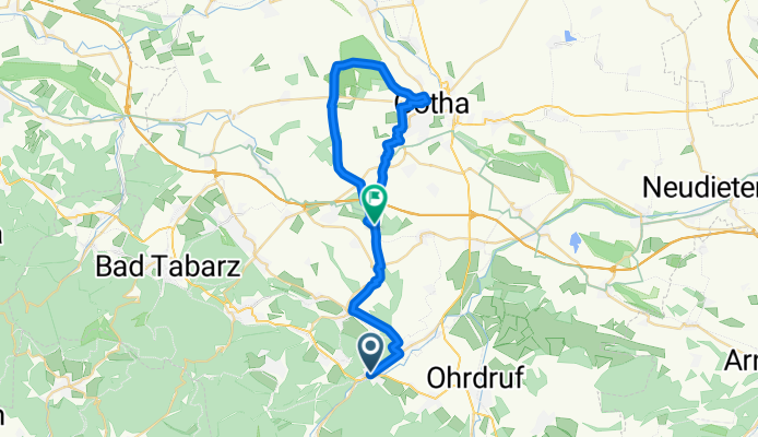
Trip from Georgenthal to the Citizens' Tower in Gotha, a very beautiful route through forest and fields, then a wonderful reward with a panoramic view from the Citizens' Tower.
- -:--
- Duration
- 34.1 km
- Distance
- 351 m
- Ascent
- 381 m
- Descent
- ---
- Avg. speed
- ---
- Max. altitude
Route highlights
Points of interest along the route
Point of interest after 24.6 km
Krahnberg Bürgerturm
Continue with Bikemap
Use, edit, or download this cycling route
You would like to ride Ausflug zum Bürgerturm Krahnberg b. Gotha or customize it for your own trip? Here is what you can do with this Bikemap route:
Free features
- Save this route as favorite or in collections
- Copy & plan your own version of this route
- Sync your route with Garmin or Wahoo
Premium features
Free trial for 3 days, or one-time payment. More about Bikemap Premium.
- Navigate this route on iOS & Android
- Export a GPX / KML file of this route
- Create your custom printout (try it for free)
- Download this route for offline navigation
Discover more Premium features.
Get Bikemap PremiumFrom our community
Other popular routes starting in Georgenthal
 Flössgraben
- Distance
- 26.3 km
- Ascent
- 196 m
- Descent
- 196 m
- Location
- Georgenthal, Thuringia, Germany
 Sauriererlebnispfad Georgenthal
- Distance
- 6.1 km
- Ascent
- 86 m
- Descent
- 97 m
- Location
- Georgenthal, Thuringia, Germany
 Kirchweg 2, Leinatal nach Kirchweg 2, Leinatal
- Distance
- 29.4 km
- Ascent
- 665 m
- Descent
- 665 m
- Location
- Georgenthal, Thuringia, Germany
 Georgenthal IG Hirzbergbahn - Gotha
- Distance
- 19.2 km
- Ascent
- 61 m
- Descent
- 136 m
- Location
- Georgenthal, Thuringia, Germany
 20170219_121347.gpx
- Distance
- 3.2 km
- Ascent
- 30 m
- Descent
- 59 m
- Location
- Georgenthal, Thuringia, Germany
 Ausflug zum Bürgerturm Krahnberg b. Gotha
- Distance
- 34.1 km
- Ascent
- 351 m
- Descent
- 381 m
- Location
- Georgenthal, Thuringia, Germany
 2016-06-25 Eisenach - dann Bahn nach Hamburg
- Distance
- 44.3 km
- Ascent
- 147 m
- Descent
- 321 m
- Location
- Georgenthal, Thuringia, Germany
 Gemütliche Route in Leinatal
- Distance
- 43.5 km
- Ascent
- 811 m
- Descent
- 829 m
- Location
- Georgenthal, Thuringia, Germany
Open it in the app