

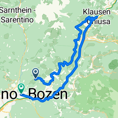
Ritten ab Seilfahrt bis Bozen Parken 50km
A cycling route starting in Soprabolzano, Trentino-Alto Adige, Italy.
Overview
About this route
- -:--
- Duration
- 50.3 km
- Distance
- 773 m
- Ascent
- 1,750 m
- Descent
- ---
- Avg. speed
- 1,228 m
- Max. altitude

Route quality
Waytypes & surfaces along the route
Waytypes
Busy road
18.7 km
(37 %)
Cycleway
12.8 km
(25 %)
Surfaces
Paved
43.3 km
(86 %)
Unpaved
0.2 km
(<1 %)
Asphalt
42.6 km
(85 %)
Paved (undefined)
0.6 km
(1 %)
Continue with Bikemap
Use, edit, or download this cycling route
You would like to ride Ritten ab Seilfahrt bis Bozen Parken 50km or customize it for your own trip? Here is what you can do with this Bikemap route:
Free features
- Save this route as favorite or in collections
- Copy & plan your own version of this route
- Sync your route with Garmin or Wahoo
Premium features
Free trial for 3 days, or one-time payment. More about Bikemap Premium.
- Navigate this route on iOS & Android
- Export a GPX / KML file of this route
- Create your custom printout (try it for free)
- Download this route for offline navigation
Discover more Premium features.
Get Bikemap PremiumFrom our community
Other popular routes starting in Soprabolzano
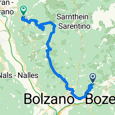
 Klausen
- Distance
- 59.3 km
- Ascent
- 506 m
- Descent
- 1,442 m
- Location
- Soprabolzano, Trentino-Alto Adige, Italy
 Soprabolzano-Vanga-Pennes-Bressanone-Soprabolzano
- Distance
- 134 km
- Ascent
- 3,853 m
- Descent
- 3,801 m
- Location
- Soprabolzano, Trentino-Alto Adige, Italy
 Oberbozen 510
- Distance
- 19.3 km
- Ascent
- 554 m
- Descent
- 556 m
- Location
- Soprabolzano, Trentino-Alto Adige, Italy
 06.05.16 Soprabolzano - Kalterer See - Bozen
- Distance
- 95.4 km
- Ascent
- 655 m
- Descent
- 1,596 m
- Location
- Soprabolzano, Trentino-Alto Adige, Italy
 Ritten ab Seilfahrt bis Bozen Parken 50km
- Distance
- 50.3 km
- Ascent
- 773 m
- Descent
- 1,750 m
- Location
- Soprabolzano, Trentino-Alto Adige, Italy
 Route 2019 E3
- Distance
- 44 km
- Ascent
- 1,933 m
- Descent
- 1,809 m
- Location
- Soprabolzano, Trentino-Alto Adige, Italy
 04.05.2016, Lange Runde Bozen-Leifers-Sarntal
- Distance
- 83.9 km
- Ascent
- 1,281 m
- Descent
- 1,281 m
- Location
- Soprabolzano, Trentino-Alto Adige, Italy
 Anello Soprabolzano-Corno del Renon-Toten kirche
- Distance
- 24.7 km
- Ascent
- 1,290 m
- Descent
- 390 m
- Location
- Soprabolzano, Trentino-Alto Adige, Italy
Open it in the app