

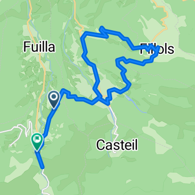
COL DE LA LLOSE (por Olette)
A cycling route starting in Vernet-les-Bains, Occitanie, France.
Overview
About this route
- -:--
- Duration
- 24.4 km
- Distance
- 1,490 m
- Ascent
- 252 m
- Descent
- ---
- Avg. speed
- 1,866 m
- Max. altitude

Route quality
Waytypes & surfaces along the route
Waytypes
Road
24.4 km
(100 %)
Continue with Bikemap
Use, edit, or download this cycling route
You would like to ride COL DE LA LLOSE (por Olette) or customize it for your own trip? Here is what you can do with this Bikemap route:
Free features
- Save this route as favorite or in collections
- Copy & plan your own version of this route
- Sync your route with Garmin or Wahoo
Premium features
Free trial for 3 days, or one-time payment. More about Bikemap Premium.
- Navigate this route on iOS & Android
- Export a GPX / KML file of this route
- Create your custom printout (try it for free)
- Download this route for offline navigation
Discover more Premium features.
Get Bikemap PremiumFrom our community
Other popular routes starting in Vernet-les-Bains
 Les Garrotxes
- Distance
- 60.4 km
- Ascent
- 1,463 m
- Descent
- 1,458 m
- Location
- Vernet-les-Bains, Occitanie, France
 Sahorre to Rue de las Closes, Sahorre
- Distance
- 19.5 km
- Ascent
- 425 m
- Descent
- 405 m
- Location
- Vernet-les-Bains, Occitanie, France
 VTTistes pas touristes 2016 2/4
- Distance
- 32.9 km
- Ascent
- 1,844 m
- Descent
- 1,595 m
- Location
- Vernet-les-Bains, Occitanie, France
 20180626 Camí de Menut
- Distance
- 3.9 km
- Ascent
- 2,796 m
- Descent
- 2,793 m
- Location
- Vernet-les-Bains, Occitanie, France
 TDP - ETAPE 14
- Distance
- 73.9 km
- Ascent
- 757 m
- Descent
- 1,202 m
- Location
- Vernet-les-Bains, Occitanie, France
 Tanspirinaica.1
- Distance
- 105.3 km
- Ascent
- 2,378 m
- Descent
- 1,810 m
- Location
- Vernet-les-Bains, Occitanie, France
 Chemin de la Cooperative, Corneilla-de-Conflent à Los Pastorals, Corneilla-de-Conflent
- Distance
- 27.1 km
- Ascent
- 906 m
- Descent
- 853 m
- Location
- Vernet-les-Bains, Occitanie, France
 Foix - Mantet
- Distance
- 172.6 km
- Ascent
- 2,872 m
- Descent
- 3,978 m
- Location
- Vernet-les-Bains, Occitanie, France
Open it in the app