

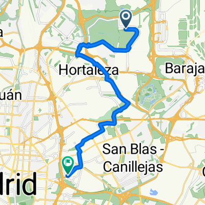
Carril bici Madrid. Anillo Ciclista
A cycling route starting in Hortaleza, Madrid, Spain.
Overview
About this route
Green ring of Madrid
- -:--
- Duration
- 69.8 km
- Distance
- 412 m
- Ascent
- 412 m
- Descent
- ---
- Avg. speed
- ---
- Max. altitude
Continue with Bikemap
Use, edit, or download this cycling route
You would like to ride Carril bici Madrid. Anillo Ciclista or customize it for your own trip? Here is what you can do with this Bikemap route:
Free features
- Save this route as favorite or in collections
- Copy & plan your own version of this route
- Sync your route with Garmin or Wahoo
Premium features
Free trial for 3 days, or one-time payment. More about Bikemap Premium.
- Navigate this route on iOS & Android
- Export a GPX / KML file of this route
- Create your custom printout (try it for free)
- Download this route for offline navigation
Discover more Premium features.
Get Bikemap PremiumFrom our community
Other popular routes starting in Hortaleza
 Easy ride
- Distance
- 15.1 km
- Ascent
- 130 m
- Descent
- 169 m
- Location
- Hortaleza, Madrid, Spain
 test app , Short ride from May 15, 9:14 PM
- Distance
- 6.2 km
- Ascent
- 124 m
- Descent
- 85 m
- Location
- Hortaleza, Madrid, Spain
 coffee stop!
- Distance
- 8.5 km
- Ascent
- 67 m
- Descent
- 140 m
- Location
- Hortaleza, Madrid, Spain
 Daganzo Day Out
- Distance
- 18.6 km
- Ascent
- 246 m
- Descent
- 252 m
- Location
- Hortaleza, Madrid, Spain
 Sunday different route
- Distance
- 16.5 km
- Ascent
- 178 m
- Descent
- 210 m
- Location
- Hortaleza, Madrid, Spain
 closed by Norwegian houses
- Distance
- 20 km
- Ascent
- 268 m
- Descent
- 313 m
- Location
- Hortaleza, Madrid, Spain
 Sanchinarro-Valdelatas-Dehesaboyal-Trescantos
- Distance
- 43.8 km
- Ascent
- 349 m
- Descent
- 349 m
- Location
- Hortaleza, Madrid, Spain
 opticalia
- Distance
- 11.5 km
- Ascent
- 169 m
- Descent
- 109 m
- Location
- Hortaleza, Madrid, Spain
Open it in the app