Wassertour (neu)
A cycling route starting in Bodenteich, Lower Saxony, Germany.
Overview
About this route
Das Thema „Wasser“ begleitet diese besondere Tagestour: Von Bad Bodenteich („400-Wasser-Barfußpfad“) geht es entlang der Wierener Dorfteiche und dem Themenpfad „Wasser macht’s möglich“ zur Schleusengruppe Uelzen am Elbe-Seitenkanal. Nach dem „Hundertwasser-Bahnhof“ warten die alte Wassermühle Holxen, der „Wassererlebnis-Pfad Hardautal“ und der „Hardausee“ auf Sie. Ersatzakku/Ladekabel empfohlen. Unser Tipp: Eine Tretbootfahrt auf dem Teicherlebnispfad im Bodenteicher Kurpark am See.
- -:--
- Duration
- 67.9 km
- Distance
- 200 m
- Ascent
- 200 m
- Descent
- ---
- Avg. speed
- ---
- Avg. speed
Route quality
Waytypes & surfaces along the route
Waytypes
Quiet road
22 km
(32 %)
Track
10 km
(15 %)
Surfaces
Paved
33.8 km
(50 %)
Unpaved
11.1 km
(16 %)
Asphalt
28.3 km
(42 %)
Unpaved (undefined)
5.5 km
(8 %)
Continue with Bikemap
Use, edit, or download this cycling route
You would like to ride Wassertour (neu) or customize it for your own trip? Here is what you can do with this Bikemap route:
Free features
- Save this route as favorite or in collections
- Copy & plan your own version of this route
- Sync your route with Garmin or Wahoo
Premium features
Free trial for 3 days, or one-time payment. More about Bikemap Premium.
- Navigate this route on iOS & Android
- Export a GPX / KML file of this route
- Create your custom printout (try it for free)
- Download this route for offline navigation
Discover more Premium features.
Get Bikemap PremiumFrom our community
Other popular routes starting in Bodenteich
- Triathlon Bad Bodenteich 08 (Volksdist., Radsplit)
- Distance
- 30 km
- Ascent
- 140 m
- Descent
- 137 m
- Location
- Bodenteich, Lower Saxony, Germany
- Alte Ritter wilde Pferde
- Distance
- 45.2 km
- Ascent
- 86 m
- Descent
- 86 m
- Location
- Bodenteich, Lower Saxony, Germany
- Otter und Heide
- Distance
- 45.5 km
- Ascent
- 140 m
- Descent
- 137 m
- Location
- Bodenteich, Lower Saxony, Germany
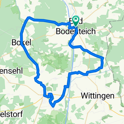
- Bad Bodenteich - Platendorf
- Distance
- 55.6 km
- Ascent
- 168 m
- Descent
- 178 m
- Location
- Bodenteich, Lower Saxony, Germany
- Ottertour
- Distance
- 53.5 km
- Ascent
- 135 m
- Descent
- 139 m
- Location
- Bodenteich, Lower Saxony, Germany
- Vorbei an Burgen und MĂĽhlen
- Distance
- 39 km
- Ascent
- 128 m
- Descent
- 128 m
- Location
- Bodenteich, Lower Saxony, Germany
- Technik und Handwerk
- Distance
- 36.1 km
- Ascent
- 135 m
- Descent
- 135 m
- Location
- Bodenteich, Lower Saxony, Germany
- Bäckertour
- Distance
- 46.8 km
- Ascent
- 117 m
- Descent
- 118 m
- Location
- Bodenteich, Lower Saxony, Germany
Open it in the app