
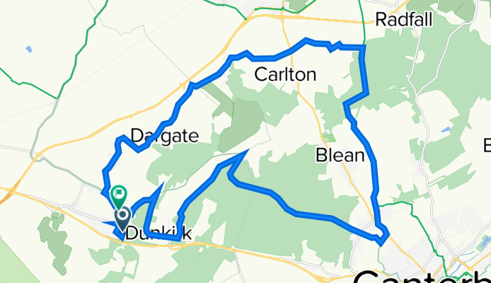
Thursday Route
A cycling route starting in Dunkirk, England, United Kingdom.
Overview
About this route
The route consists mainly of country lanes, Blean woods gravel track, Crab and winkle cycle path
- -:--
- Duration
- 26.6 km
- Distance
- 278 m
- Ascent
- 293 m
- Descent
- ---
- Avg. speed
- 124 m
- Avg. speed
Route quality
Waytypes & surfaces along the route
Waytypes
Quiet road
9.3 km
(35 %)
Cycleway
5.8 km
(22 %)
Surfaces
Paved
9.6 km
(36 %)
Unpaved
7.8 km
(29 %)
Asphalt
9.6 km
(36 %)
Gravel
5.6 km
(21 %)
Continue with Bikemap
Use, edit, or download this cycling route
You would like to ride Thursday Route or customize it for your own trip? Here is what you can do with this Bikemap route:
Free features
- Save this route as favorite or in collections
- Copy & plan your own version of this route
- Sync your route with Garmin or Wahoo
Premium features
Free trial for 3 days, or one-time payment. More about Bikemap Premium.
- Navigate this route on iOS & Android
- Export a GPX / KML file of this route
- Create your custom printout (try it for free)
- Download this route for offline navigation
Discover more Premium features.
Get Bikemap PremiumFrom our community
Other popular routes starting in Dunkirk
 Staple Street 1, Hernhill to Old Dover Road 21
- Distance
- 15 km
- Ascent
- 96 m
- Descent
- 161 m
- Location
- Dunkirk, England, United Kingdom
 Thursday Route
- Distance
- 26.6 km
- Ascent
- 278 m
- Descent
- 293 m
- Location
- Dunkirk, England, United Kingdom
 40 Saint Pauls Road, Faversham to Garlinge Green Road, Canterbury
- Distance
- 12.3 km
- Ascent
- 182 m
- Descent
- 171 m
- Location
- Dunkirk, England, United Kingdom
 Local 50k
- Distance
- 51.2 km
- Ascent
- 568 m
- Descent
- 565 m
- Location
- Dunkirk, England, United Kingdom
 River stour
- Distance
- 26.5 km
- Ascent
- 214 m
- Descent
- 214 m
- Location
- Dunkirk, England, United Kingdom
 Faversham to Sandwich
- Distance
- 43.3 km
- Ascent
- 234 m
- Descent
- 271 m
- Location
- Dunkirk, England, United Kingdom
 Waterham Business Park, 151 Highstreet Road, Faversham to 100 Deanwood Dr, Gillingham
- Distance
- 30.9 km
- Ascent
- 274 m
- Descent
- 188 m
- Location
- Dunkirk, England, United Kingdom
 Waterham Business Park, 151 Highstreet Road, Faversham to 100 Deanwood Dr, Gillingham
- Distance
- 30.9 km
- Ascent
- 274 m
- Descent
- 188 m
- Location
- Dunkirk, England, United Kingdom
Open it in the app