

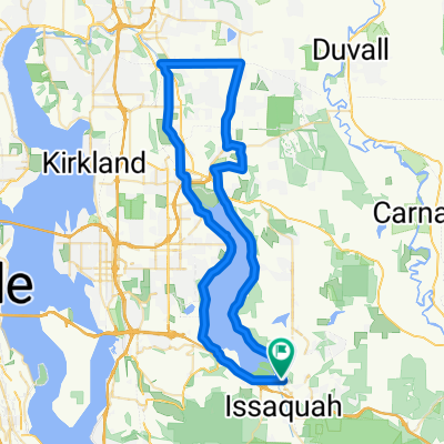
Front Street North 121, Issaquah to Southeast 38th Street 15430, Bellevue
A cycling route starting in Issaquah, Washington, United States.
Overview
About this route
- 47 min
- Duration
- 11.7 km
- Distance
- 121 m
- Ascent
- 27 m
- Descent
- 15 km/h
- Avg. speed
- 124 m
- Max. altitude

Route quality
Waytypes & surfaces along the route
Waytypes
Cycleway
6.5 km
(56 %)
Road
4 km
(34 %)
Surfaces
Paved
11.5 km
(98 %)
Asphalt
8.5 km
(73 %)
Concrete
1.8 km
(15 %)
Continue with Bikemap
Use, edit, or download this cycling route
You would like to ride Front Street North 121, Issaquah to Southeast 38th Street 15430, Bellevue or customize it for your own trip? Here is what you can do with this Bikemap route:
Free features
- Save this route as favorite or in collections
- Copy & plan your own version of this route
- Sync your route with Garmin or Wahoo
Premium features
Free trial for 3 days, or one-time payment. More about Bikemap Premium.
- Navigate this route on iOS & Android
- Export a GPX / KML file of this route
- Create your custom printout (try it for free)
- Download this route for offline navigation
Discover more Premium features.
Get Bikemap PremiumFrom our community
Other popular routes starting in Issaquah
 220th Avenue Southeast 5506, Issaquah to 220th Avenue Southeast 5506, Issaquah
- Distance
- 53.2 km
- Ascent
- 40 m
- Descent
- 43 m
- Location
- Issaquah, Washington, United States
 Highlands
- Distance
- 4.6 km
- Ascent
- 91 m
- Descent
- 158 m
- Location
- Issaquah, Washington, United States
 Recovered Route
- Distance
- 41.4 km
- Ascent
- 208 m
- Descent
- 192 m
- Location
- Issaquah, Washington, United States
 Front Street North 121, Issaquah to Southeast 38th Street 15430, Bellevue
- Distance
- 11.7 km
- Ascent
- 121 m
- Descent
- 27 m
- Location
- Issaquah, Washington, United States
 224th Ave SE, Issaquah to 224th Ave SE, Issaquah
- Distance
- 11.1 km
- Ascent
- 10 m
- Descent
- 10 m
- Location
- Issaquah, Washington, United States
 North Maple Valley
- Distance
- 45.9 km
- Ascent
- 339 m
- Descent
- 338 m
- Location
- Issaquah, Washington, United States
 Ride around Lake Sammamish and beyond.
- Distance
- 59.8 km
- Ascent
- 278 m
- Descent
- 279 m
- Location
- Issaquah, Washington, United States
 2142–2198 Tiger View Ct NW, Issaquah to Marymoor Connector Trail, Redmond
- Distance
- 20.4 km
- Ascent
- 124 m
- Descent
- 261 m
- Location
- Issaquah, Washington, United States
Open it in the app