

Wangen Donaueschingen/Donautal 2022
#1 Wangen - Donaueschingen
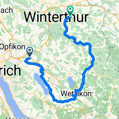
A cycling route starting in Wangen, Canton of Zurich, Switzerland.
Overview
About this route
- -:--
- Duration
- 83.1 km
- Distance
- 1,166 m
- Ascent
- 938 m
- Descent
- ---
- Avg. speed
- 786 m
- Max. altitude

Part of
Route quality
Waytypes & surfaces along the route
Waytypes
Road
36.6 km
(44 %)
Quiet road
15 km
(18 %)
Surfaces
Paved
64.8 km
(78 %)
Unpaved
5.8 km
(7 %)
Asphalt
62.3 km
(75 %)
Gravel
4.2 km
(5 %)
Continue with Bikemap
Use, edit, or download this cycling route
You would like to ride #1 Wangen - Donaueschingen or customize it for your own trip? Here is what you can do with this Bikemap route:
Free features
- Save this route as favorite or in collections
- Copy & plan your own version of this route
- Split it into stages to create a multi-day tour
- Sync your route with Garmin or Wahoo
Premium features
Free trial for 3 days, or one-time payment. More about Bikemap Premium.
- Navigate this route on iOS & Android
- Export a GPX / KML file of this route
- Create your custom printout (try it for free)
- Download this route for offline navigation
Discover more Premium features.
Get Bikemap PremiumFrom our community
Other popular routes starting in Wangen
 Schleife durchs Wehratal von Wangen/ZH aus
- Distance
- 174.2 km
- Ascent
- 1,459 m
- Descent
- 1,459 m
- Location
- Wangen, Canton of Zurich, Switzerland
 Bodenseerunde ab Wangen
- Distance
- 226.6 km
- Ascent
- 1,458 m
- Descent
- 1,498 m
- Location
- Wangen, Canton of Zurich, Switzerland
 Dübi - dürstelen - Hulftegg - ricken - Volki
- Distance
- 103.1 km
- Ascent
- 960 m
- Descent
- 924 m
- Location
- Wangen, Canton of Zurich, Switzerland
 Stadtwanderung Glattal um den Dübendorfer Flugplatz
- Distance
- 8.9 km
- Ascent
- 25 m
- Descent
- 25 m
- Location
- Wangen, Canton of Zurich, Switzerland
 dübendorf - Wetzikon - saland - winterthur
- Distance
- 57.3 km
- Ascent
- 358 m
- Descent
- 329 m
- Location
- Wangen, Canton of Zurich, Switzerland
 Wangen - Nice 2019 total
- Distance
- 1,000.2 km
- Ascent
- 8,664 m
- Descent
- 9,104 m
- Location
- Wangen, Canton of Zurich, Switzerland
 Rogers Greifensee Rundfahrt
- Distance
- 38.5 km
- Ascent
- 302 m
- Descent
- 303 m
- Location
- Wangen, Canton of Zurich, Switzerland
 Wangen - Kaltern
- Distance
- 480.8 km
- Ascent
- 0 m
- Descent
- 0 m
- Location
- Wangen, Canton of Zurich, Switzerland
Open it in the app