

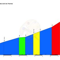
Port de Pailheres
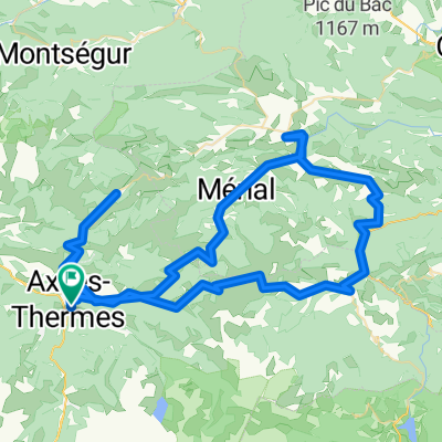
A cycling route starting in Ax-les-Thermes, Occitanie, France.
Overview
About this route
Demanding ascent of more than 19 km at almost 8%, last 6 km hellish above 9%. Spectacular!!!!!!!!
- -:--
- Duration
- 37.9 km
- Distance
- 1,291 m
- Ascent
- 1,290 m
- Descent
- ---
- Avg. speed
- ---
- Max. altitude

Route quality
Waytypes & surfaces along the route
Surfaces
Paved
29.9 km
(79 %)
Asphalt
29.9 km
(79 %)
Undefined
8 km
(21 %)
Route highlights
Points of interest along the route
Point of interest after 18.9 km
Col de Pailheres, 19,5km al 7,9%
Continue with Bikemap
Use, edit, or download this cycling route
You would like to ride Port de Pailheres or customize it for your own trip? Here is what you can do with this Bikemap route:
Free features
- Save this route as favorite or in collections
- Copy & plan your own version of this route
- Sync your route with Garmin or Wahoo
Premium features
Free trial for 3 days, or one-time payment. More about Bikemap Premium.
- Navigate this route on iOS & Android
- Export a GPX / KML file of this route
- Create your custom printout (try it for free)
- Download this route for offline navigation
Discover more Premium features.
Get Bikemap PremiumFrom our community
Other popular routes starting in Ax-les-Thermes
 Ax-les-Thermes 2
- Distance
- 108.6 km
- Ascent
- 2,793 m
- Descent
- 2,790 m
- Location
- Ax-les-Thermes, Occitanie, France
 Ax-les-Thermes 1
- Distance
- 82.5 km
- Ascent
- 2,939 m
- Descent
- 2,941 m
- Location
- Ax-les-Thermes, Occitanie, France
 Pirinei-07
- Distance
- 91.4 km
- Ascent
- 2,756 m
- Descent
- 3,142 m
- Location
- Ax-les-Thermes, Occitanie, France
 2012 T6
- Distance
- 169.8 km
- Ascent
- 1,579 m
- Descent
- 2,300 m
- Location
- Ax-les-Thermes, Occitanie, France
 Ax-les-Thermes - Col Ascou Palhières - Col du pradel - Ax Bonascre
- Distance
- 74.8 km
- Ascent
- 2,432 m
- Descent
- 2,433 m
- Location
- Ax-les-Thermes, Occitanie, France
 3. Etappe: Ax les Thermes - Massad
- Distance
- 100.8 km
- Ascent
- 2,475 m
- Descent
- 2,535 m
- Location
- Ax-les-Thermes, Occitanie, France
 2) Ax-Les-Thermes Route 3
- Distance
- 81.7 km
- Ascent
- 2,412 m
- Descent
- 2,413 m
- Location
- Ax-les-Thermes, Occitanie, France
 2015 AND Etapa 6 Pailhères
- Distance
- 113.8 km
- Ascent
- 3,077 m
- Descent
- 3,078 m
- Location
- Ax-les-Thermes, Occitanie, France
Open it in the app