
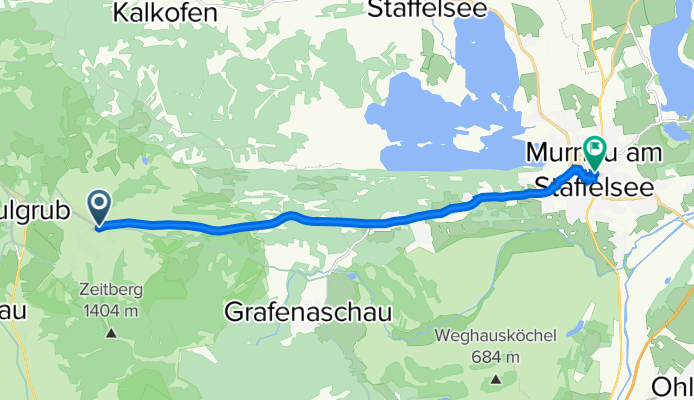
murnau-kohlgrub
A cycling route starting in Bad Kohlgrub, Bavaria, Germany.
Overview
About this route
- 44 min
- Duration
- 12 km
- Distance
- 97 m
- Ascent
- 240 m
- Descent
- 16.4 km/h
- Avg. speed
- 826 m
- Avg. speed
Route quality
Waytypes & surfaces along the route
Waytypes
Busy road
7.8 km
(64 %)
Path
2.2 km
(18 %)
Surfaces
Paved
11.9 km
(99 %)
Unpaved
0.1 km
(<1 %)
Asphalt
11.2 km
(93 %)
Paved (undefined)
0.5 km
(5 %)
Continue with Bikemap
Use, edit, or download this cycling route
You would like to ride murnau-kohlgrub or customize it for your own trip? Here is what you can do with this Bikemap route:
Free features
- Save this route as favorite or in collections
- Copy & plan your own version of this route
- Sync your route with Garmin or Wahoo
Premium features
Free trial for 3 days, or one-time payment. More about Bikemap Premium.
- Navigate this route on iOS & Android
- Export a GPX / KML file of this route
- Create your custom printout (try it for free)
- Download this route for offline navigation
Discover more Premium features.
Get Bikemap PremiumFrom our community
Other popular routes starting in Bad Kohlgrub
 Bad Kohlgrub - Linderhof
- Distance
- 24.1 km
- Ascent
- 352 m
- Descent
- 249 m
- Location
- Bad Kohlgrub, Bavaria, Germany
 Wanderung - Schwaigrohr-Rundweg
- Distance
- 3.7 km
- Ascent
- 92 m
- Descent
- 91 m
- Location
- Bad Kohlgrub, Bavaria, Germany
 Bad Kohlgrun nach Füssen
- Distance
- 41.7 km
- Ascent
- 502 m
- Descent
- 522 m
- Location
- Bad Kohlgrub, Bavaria, Germany
 Ettaler Runde
- Distance
- 17.1 km
- Ascent
- 162 m
- Descent
- 107 m
- Location
- Bad Kohlgrub, Bavaria, Germany
 Schneeschuhwanderung - Stierkopf
- Distance
- 10.3 km
- Ascent
- 446 m
- Descent
- 940 m
- Location
- Bad Kohlgrub, Bavaria, Germany
 Bad Kohlgrub - Oberhausen
- Distance
- 17.1 km
- Ascent
- 55 m
- Descent
- 296 m
- Location
- Bad Kohlgrub, Bavaria, Germany
 Staffelsee runde
- Distance
- 32.4 km
- Ascent
- 376 m
- Descent
- 376 m
- Location
- Bad Kohlgrub, Bavaria, Germany
 Bad Kohlgrub nach Hopfensee
- Distance
- 43 km
- Ascent
- 437 m
- Descent
- 477 m
- Location
- Bad Kohlgrub, Bavaria, Germany
Open it in the app