

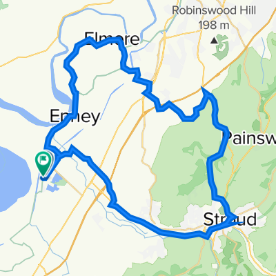
Ebley to Coaley Peak Circular
A cycling route starting in Stonehouse, England, United Kingdom.
Overview
About this route
Hilly blast around Stroud – decent speedy downhill stretches
- 1 h 55 min
- Duration
- 16.3 km
- Distance
- 270 m
- Ascent
- 270 m
- Descent
- 8.5 km/h
- Avg. speed
- 240 m
- Max. altitude

Continue with Bikemap
Use, edit, or download this cycling route
You would like to ride Ebley to Coaley Peak Circular or customize it for your own trip? Here is what you can do with this Bikemap route:
Free features
- Save this route as favorite or in collections
- Copy & plan your own version of this route
- Sync your route with Garmin or Wahoo
Premium features
Free trial for 3 days, or one-time payment. More about Bikemap Premium.
- Navigate this route on iOS & Android
- Export a GPX / KML file of this route
- Create your custom printout (try it for free)
- Download this route for offline navigation
Discover more Premium features.
Get Bikemap PremiumFrom our community
Other popular routes starting in Stonehouse
 Frampton loop of love
- Distance
- 24.5 km
- Ascent
- 80 m
- Descent
- 81 m
- Location
- Stonehouse, England, United Kingdom
 National Cycle Network 45 (Mercian Way) Ebley - Cirencester
- Distance
- 33.3 km
- Ascent
- 351 m
- Descent
- 279 m
- Location
- Stonehouse, England, United Kingdom
 home to Leonard Stanley, Nailsworth, reyford, home
- Distance
- 21.7 km
- Ascent
- 200 m
- Descent
- 205 m
- Location
- Stonehouse, England, United Kingdom
 berkley vale
- Distance
- 95.8 km
- Ascent
- 81 m
- Descent
- 81 m
- Location
- Stonehouse, England, United Kingdom
 Sandfield Bridgehouse, Church Lane, Gloucester to Saintbridge Road, Gloucester
- Distance
- 19.2 km
- Ascent
- 65 m
- Descent
- 51 m
- Location
- Stonehouse, England, United Kingdom
 Frocester and Crawley Hill
- Distance
- 25.6 km
- Ascent
- 426 m
- Descent
- 426 m
- Location
- Stonehouse, England, United Kingdom
 thursday loop
- Distance
- 45.3 km
- Ascent
- 310 m
- Descent
- 313 m
- Location
- Stonehouse, England, United Kingdom
 Ebley to Coaley Peak Circular
- Distance
- 16.3 km
- Ascent
- 270 m
- Descent
- 270 m
- Location
- Stonehouse, England, United Kingdom
Open it in the app