

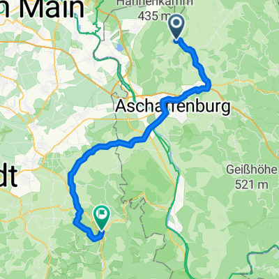
Ehemaliger Eu-Mittelpunkt und Kahlgrund
A cycling route starting in Mömbris, Bavaria, Germany.
Overview
About this route
slightly hilly tour through the meadows of Kahlgrund and the heights of Vorspessart
- 2 h 4 min
- Duration
- 30.7 km
- Distance
- 447 m
- Ascent
- 447 m
- Descent
- 14.8 km/h
- Avg. speed
- 333 m
- Max. altitude

Route photos

Route quality
Waytypes & surfaces along the route
Waytypes
Track
13.8 km
(45 %)
Quiet road
12.9 km
(42 %)
Surfaces
Paved
16.6 km
(54 %)
Unpaved
6.5 km
(21 %)
Asphalt
14.1 km
(46 %)
Gravel
6.5 km
(21 %)
Route highlights
Points of interest along the route

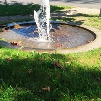
Photo after 15.2 km
Ehemaliger Mittelpunkt der EU
Continue with Bikemap
Use, edit, or download this cycling route
You would like to ride Ehemaliger Eu-Mittelpunkt und Kahlgrund or customize it for your own trip? Here is what you can do with this Bikemap route:
Free features
- Save this route as favorite or in collections
- Copy & plan your own version of this route
- Sync your route with Garmin or Wahoo
Premium features
Free trial for 3 days, or one-time payment. More about Bikemap Premium.
- Navigate this route on iOS & Android
- Export a GPX / KML file of this route
- Create your custom printout (try it for free)
- Download this route for offline navigation
Discover more Premium features.
Get Bikemap PremiumFrom our community
Other popular routes starting in Mömbris
 Rund um den Hahnenkamm
- Distance
- 39.9 km
- Ascent
- 363 m
- Descent
- 363 m
- Location
- Mömbris, Bavaria, Germany
 von Strötzbach zum Engländer und zurück
- Distance
- 45.2 km
- Ascent
- 453 m
- Descent
- 452 m
- Location
- Mömbris, Bavaria, Germany
 Aschaffenburg (Daxberg) - Großglockner
- Distance
- 550.7 km
- Ascent
- 3,412 m
- Descent
- 1,158 m
- Location
- Mömbris, Bavaria, Germany
 Runde A'burg Umland
- Distance
- 47.3 km
- Ascent
- 882 m
- Descent
- 875 m
- Location
- Mömbris, Bavaria, Germany
 Berg und Tal
- Distance
- 46.7 km
- Ascent
- 731 m
- Descent
- 729 m
- Location
- Mömbris, Bavaria, Germany
 Freigerichttour 22
- Distance
- 53.9 km
- Ascent
- 413 m
- Descent
- 411 m
- Location
- Mömbris, Bavaria, Germany
 Mömbris - Walldürn
- Distance
- 83.6 km
- Ascent
- 597 m
- Descent
- 445 m
- Location
- Mömbris, Bavaria, Germany
 2ter Tag alternative
- Distance
- 56.8 km
- Ascent
- 345 m
- Descent
- 369 m
- Location
- Mömbris, Bavaria, Germany
Open it in the app