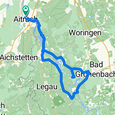
Aitrach - Diepoldshofen - Seibranz - Rot/Rot - Aitrach
A cycling route starting in Aitrach, Baden-Württemberg, Germany.
Overview
About this route
Rundkurs - teils flach - teils hügelig - auf größtensteils verkehrsarmen Straßen und Radwegen.
- -:--
- Duration
- 55 km
- Distance
- 306 m
- Ascent
- 303 m
- Descent
- ---
- Avg. speed
- ---
- Avg. speed
Route quality
Waytypes & surfaces along the route
Waytypes
Road
20.3 km
(37 %)
Quiet road
17.5 km
(32 %)
Surfaces
Paved
30.6 km
(56 %)
Asphalt
26.4 km
(48 %)
Paved (undefined)
4.2 km
(8 %)
Undefined
24.4 km
(44 %)
Continue with Bikemap
Use, edit, or download this cycling route
You would like to ride Aitrach - Diepoldshofen - Seibranz - Rot/Rot - Aitrach or customize it for your own trip? Here is what you can do with this Bikemap route:
Free features
- Save this route as favorite or in collections
- Copy & plan your own version of this route
- Sync your route with Garmin or Wahoo
Premium features
Free trial for 3 days, or one-time payment. More about Bikemap Premium.
- Navigate this route on iOS & Android
- Export a GPX / KML file of this route
- Create your custom printout (try it for free)
- Download this route for offline navigation
Discover more Premium features.
Get Bikemap PremiumFrom our community
Other popular routes starting in Aitrach
- Aitrach - Diepoldshofen - Seibranz - Rot/Rot - Aitrach
- Distance
- 55 km
- Ascent
- 306 m
- Descent
- 303 m
- Location
- Aitrach, Baden-Württemberg, Germany
- Aitrach - Alcazar
- Distance
- 57.2 km
- Ascent
- 332 m
- Descent
- 332 m
- Location
- Aitrach, Baden-Württemberg, Germany
- Aitrach - Erolzheim - Aitrach
- Distance
- 61 km
- Ascent
- 390 m
- Descent
- 390 m
- Location
- Aitrach, Baden-Württemberg, Germany
- Rund um Memmingen
- Distance
- 64.5 km
- Ascent
- 316 m
- Descent
- 318 m
- Location
- Aitrach, Baden-Württemberg, Germany
- Radreise zum Bodensee: 5. Tag – Von Aitrach nach Lindau
- Distance
- 71.4 km
- Ascent
- 366 m
- Descent
- 556 m
- Location
- Aitrach, Baden-Württemberg, Germany
- Hügelige Tour in den Illerwinkel und ins Rotistal
- Distance
- 44.2 km
- Ascent
- 380 m
- Descent
- 380 m
- Location
- Aitrach, Baden-Württemberg, Germany
- Illertal - Rothtal - Günztal - Runde
- Distance
- 90.8 km
- Ascent
- 232 m
- Descent
- 233 m
- Location
- Aitrach, Baden-Württemberg, Germany
- Iller ab
- Distance
- 63.5 km
- Ascent
- 42 m
- Descent
- 142 m
- Location
- Aitrach, Baden-Württemberg, Germany
Open it in the app