

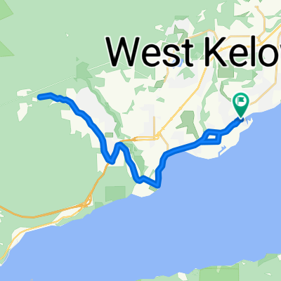
West Kelowna wine route -2
A cycling route starting in West Kelowna, British Columbia, Canada.
Overview
About this route
- -:--
- Duration
- 19.9 km
- Distance
- 310 m
- Ascent
- 309 m
- Descent
- ---
- Avg. speed
- 504 m
- Max. altitude

Route quality
Waytypes & surfaces along the route
Waytypes
Road
8.1 km
(40 %)
Quiet road
7.3 km
(37 %)
Surfaces
Paved
2.1 km
(11 %)
Paved (undefined)
2.1 km
(10 %)
Asphalt
0.1 km
(<1 %)
Undefined
17.8 km
(89 %)
Route highlights
Points of interest along the route
Point of interest after 9.3 km
Quail's gate winery
Continue with Bikemap
Use, edit, or download this cycling route
You would like to ride West Kelowna wine route -2 or customize it for your own trip? Here is what you can do with this Bikemap route:
Free features
- Save this route as favorite or in collections
- Copy & plan your own version of this route
- Sync your route with Garmin or Wahoo
Premium features
Free trial for 3 days, or one-time payment. More about Bikemap Premium.
- Navigate this route on iOS & Android
- Export a GPX / KML file of this route
- Create your custom printout (try it for free)
- Download this route for offline navigation
Discover more Premium features.
Get Bikemap PremiumFrom our community
Other popular routes starting in West Kelowna
 2573 Copper Ridge Dr, West Kelowna to 557 Groves Ave, Kelowna
- Distance
- 18.3 km
- Ascent
- 118 m
- Descent
- 332 m
- Location
- West Kelowna, British Columbia, Canada
 West Kelowna Cycling
- Distance
- 10.7 km
- Ascent
- 368 m
- Descent
- 316 m
- Location
- West Kelowna, British Columbia, Canada
 Acutruss through Kalamoir to Bridge
- Distance
- 16.8 km
- Ascent
- 256 m
- Descent
- 347 m
- Location
- West Kelowna, British Columbia, Canada
 West Kelowna Cycling
- Distance
- 25.8 km
- Ascent
- 442 m
- Descent
- 443 m
- Location
- West Kelowna, British Columbia, Canada
 388 Uplands Crt, Kelowna to 5443 Lakeshore Rd, Kelowna
- Distance
- 2.5 km
- Ascent
- 39 m
- Descent
- 61 m
- Location
- West Kelowna, British Columbia, Canada
 3746 Wetton Rd, West Kelowna to 3701–3899 Wetton Rd, West Kelowna
- Distance
- 3.9 km
- Ascent
- 80 m
- Descent
- 80 m
- Location
- West Kelowna, British Columbia, Canada
 west kelowna to kelowna
- Distance
- 14.5 km
- Ascent
- 162 m
- Descent
- 259 m
- Location
- West Kelowna, British Columbia, Canada
 West Kelowna wine route -2
- Distance
- 19.9 km
- Ascent
- 310 m
- Descent
- 309 m
- Location
- West Kelowna, British Columbia, Canada
Open it in the app