

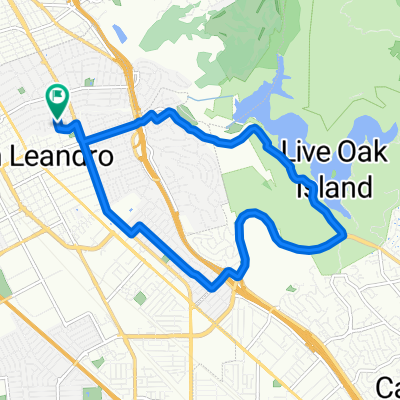
Chabot Lake-Redwood Road-Skyline Circuit
A cycling route starting in San Leandro, California, United States.
Overview
About this route
Short ride good for just getting out. Decent hill exercises coupled with OK downhills. Typically a quiet ride along Redwood, with only occasion traffic, even on a weekend. No shoulders, however.
- -:--
- Duration
- 42.4 km
- Distance
- 578 m
- Ascent
- 579 m
- Descent
- ---
- Avg. speed
- ---
- Max. altitude

Continue with Bikemap
Use, edit, or download this cycling route
You would like to ride Chabot Lake-Redwood Road-Skyline Circuit or customize it for your own trip? Here is what you can do with this Bikemap route:
Free features
- Save this route as favorite or in collections
- Copy & plan your own version of this route
- Sync your route with Garmin or Wahoo
Premium features
Free trial for 3 days, or one-time payment. More about Bikemap Premium.
- Navigate this route on iOS & Android
- Export a GPX / KML file of this route
- Create your custom printout (try it for free)
- Download this route for offline navigation
Discover more Premium features.
Get Bikemap PremiumFrom our community
Other popular routes starting in San Leandro
 SLMarina2EndOfBayTrail
- Distance
- 34 km
- Ascent
- 0 m
- Descent
- 0 m
- Location
- San Leandro, California, United States
 Chabot Lake-Redwood Road-Skyline Circuit
- Distance
- 42.4 km
- Ascent
- 578 m
- Descent
- 579 m
- Location
- San Leandro, California, United States
 Enhanced commute
- Distance
- 18 km
- Ascent
- 32 m
- Descent
- 29 m
- Location
- San Leandro, California, United States
 Lake Chabot Circuit
- Distance
- 12.8 km
- Ascent
- 237 m
- Descent
- 237 m
- Location
- San Leandro, California, United States
 San Leandro - Lake Chabot - Palomares Road - Niles Canyon Circuit
- Distance
- 58.9 km
- Ascent
- 525 m
- Descent
- 525 m
- Location
- San Leandro, California, United States
 Chabot Loop 1
- Distance
- 13 km
- Ascent
- 226 m
- Descent
- 227 m
- Location
- San Leandro, California, United States
 Lake Chabot to CV BART via Loards
- Distance
- 9.6 km
- Ascent
- 148 m
- Descent
- 148 m
- Location
- San Leandro, California, United States
 San Leandro - Alameda Loop
- Distance
- 43 km
- Ascent
- 45 m
- Descent
- 48 m
- Location
- San Leandro, California, United States
Open it in the app