

0290 m - Pas du Cerf par Pierrefeu - retour par les Borrels
A cycling route starting in Hyères, Provence-Alpes-Côte d'Azur Region, France.
Overview
About this route
- -:--
- Duration
- 46.5 km
- Distance
- 280 m
- Ascent
- 280 m
- Descent
- ---
- Avg. speed
- ---
- Max. altitude

Route quality
Waytypes & surfaces along the route
Waytypes
Road
24.6 km
(53 %)
Quiet road
2.3 km
(5 %)
Surfaces
Paved
29.8 km
(64 %)
Asphalt
29.8 km
(64 %)
Undefined
16.7 km
(36 %)
Route highlights
Points of interest along the route
Point of interest after 16.7 km
Point d'eau
Point of interest after 22.8 km
Point d'eau
Continue with Bikemap
Use, edit, or download this cycling route
You would like to ride 0290 m - Pas du Cerf par Pierrefeu - retour par les Borrels or customize it for your own trip? Here is what you can do with this Bikemap route:
Free features
- Save this route as favorite or in collections
- Copy & plan your own version of this route
- Sync your route with Garmin or Wahoo
Premium features
Free trial for 3 days, or one-time payment. More about Bikemap Premium.
- Navigate this route on iOS & Android
- Export a GPX / KML file of this route
- Create your custom printout (try it for free)
- Download this route for offline navigation
Discover more Premium features.
Get Bikemap PremiumFrom our community
Other popular routes starting in Hyères
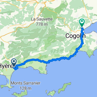 to Grimaud
- Distance
- 57 km
- Ascent
- 723 m
- Descent
- 698 m
- Location
- Hyères, Provence-Alpes-Côte d'Azur Region, France
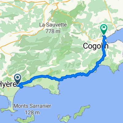 Hyere to Grimaud
- Distance
- 57 km
- Ascent
- 726 m
- Descent
- 701 m
- Location
- Hyères, Provence-Alpes-Côte d'Azur Region, France
 Itinéraire modéré en Hyères
- Distance
- 16.6 km
- Ascent
- 397 m
- Descent
- 396 m
- Location
- Hyères, Provence-Alpes-Côte d'Azur Region, France
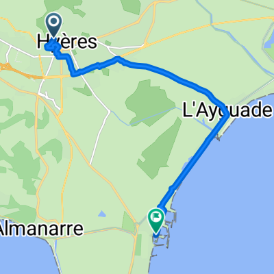
 000 Les Points d'eau
- Distance
- 0.5 km
- Ascent
- 8 m
- Descent
- 8 m
- Location
- Hyères, Provence-Alpes-Côte d'Azur Region, France
 0290 m - Pas du Cerf par Pierrefeu - retour par les Borrels
- Distance
- 46.5 km
- Ascent
- 280 m
- Descent
- 280 m
- Location
- Hyères, Provence-Alpes-Côte d'Azur Region, France
 Route to Port - Hyères
- Distance
- 9.6 km
- Ascent
- 19 m
- Descent
- 89 m
- Location
- Hyères, Provence-Alpes-Côte d'Azur Region, France
 Around Vignobles
- Distance
- 31.9 km
- Ascent
- 101 m
- Descent
- 99 m
- Location
- Hyères, Provence-Alpes-Côte d'Azur Region, France
 De Chemin de la Porte Saint-Jean 292C, Hyères à Rue du Ceinturon, Hyères
- Distance
- 10.6 km
- Ascent
- 61 m
- Descent
- 225 m
- Location
- Hyères, Provence-Alpes-Côte d'Azur Region, France
Open it in the app