

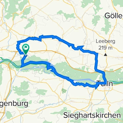
Traisen Donau
A cycling route starting in Grafenwörth, Lower Austria, Austria.
Overview
About this route
at km 10.4 cyclists' meeting at km 38.5 Puerto Velo
- -:--
- Duration
- 45.5 km
- Distance
- 194 m
- Ascent
- 194 m
- Descent
- ---
- Avg. speed
- 286 m
- Max. altitude

Route quality
Waytypes & surfaces along the route
Waytypes
Track
29.6 km
(65 %)
Road
6.4 km
(14 %)
Surfaces
Paved
39.1 km
(86 %)
Unpaved
4.5 km
(10 %)
Asphalt
39.1 km
(86 %)
Gravel
1.8 km
(4 %)
Continue with Bikemap
Use, edit, or download this cycling route
You would like to ride Traisen Donau or customize it for your own trip? Here is what you can do with this Bikemap route:
Free features
- Save this route as favorite or in collections
- Copy & plan your own version of this route
- Sync your route with Garmin or Wahoo
Premium features
Free trial for 3 days, or one-time payment. More about Bikemap Premium.
- Navigate this route on iOS & Android
- Export a GPX / KML file of this route
- Create your custom printout (try it for free)
- Download this route for offline navigation
Discover more Premium features.
Get Bikemap PremiumFrom our community
Other popular routes starting in Grafenwörth
 Wagram Tour
- Distance
- 72.8 km
- Ascent
- 244 m
- Descent
- 239 m
- Location
- Grafenwörth, Lower Austria, Austria
 Recovered Route
- Distance
- 1.5 km
- Ascent
- 0 m
- Descent
- 0 m
- Location
- Grafenwörth, Lower Austria, Austria
 Grafenwörth - Vienna
- Distance
- 61.5 km
- Ascent
- 23 m
- Descent
- 17 m
- Location
- Grafenwörth, Lower Austria, Austria
 Traisen Donau
- Distance
- 45.5 km
- Ascent
- 194 m
- Descent
- 194 m
- Location
- Grafenwörth, Lower Austria, Austria
 *7. nap Grafenwörth-Grafenegg-Langenlois-Theiss-Krems
- Distance
- 52.1 km
- Ascent
- 99 m
- Descent
- 80 m
- Location
- Grafenwörth, Lower Austria, Austria
 20120531 - Donauradweg 5
- Distance
- 67.1 km
- Ascent
- 68 m
- Descent
- 92 m
- Location
- Grafenwörth, Lower Austria, Austria
 L113, Grafenwörth nach Wiener Straße, Tulln an der Donau
- Distance
- 53 km
- Ascent
- 269 m
- Descent
- 278 m
- Location
- Grafenwörth, Lower Austria, Austria
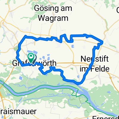 Donautour Grafenwörth
- Distance
- 37.8 km
- Ascent
- 124 m
- Descent
- 123 m
- Location
- Grafenwörth, Lower Austria, Austria
Open it in the app