

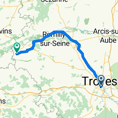
Converted from a KML file using KML2GPX.COM - Track no: 1
A cycling route starting in Saint-Julien-les-Villas, Grand Est, France.
Overview
About this route
Converted from a KML file KML2GPX.COM - This is track no: 1
- -:--
- Duration
- 127.1 km
- Distance
- 1,460 m
- Ascent
- 1,399 m
- Descent
- ---
- Avg. speed
- 347 m
- Max. altitude
Route quality
Waytypes & surfaces along the route
Waytypes
Busy road
63.5 km
(50 %)
Road
25.3 km
(20 %)
Surfaces
Paved
36.5 km
(29 %)
Unpaved
15 km
(12 %)
Asphalt
33.7 km
(26 %)
Gravel
13.3 km
(10 %)
Continue with Bikemap
Use, edit, or download this cycling route
You would like to ride Converted from a KML file using KML2GPX.COM - Track no: 1 or customize it for your own trip? Here is what you can do with this Bikemap route:
Free features
- Save this route as favorite or in collections
- Copy & plan your own version of this route
- Split it into stages to create a multi-day tour
- Sync your route with Garmin or Wahoo
Premium features
Free trial for 3 days, or one-time payment. More about Bikemap Premium.
- Navigate this route on iOS & Android
- Export a GPX / KML file of this route
- Create your custom printout (try it for free)
- Download this route for offline navigation
Discover more Premium features.
Get Bikemap PremiumFrom our community
Other popular routes starting in Saint-Julien-les-Villas
 Converted from a KML file using KML2GPX.COM - Track no: 1
- Distance
- 127.1 km
- Ascent
- 1,460 m
- Descent
- 1,399 m
- Location
- Saint-Julien-les-Villas, Grand Est, France
 De Rue Claude Monet 15, Saint-Julien-les-Villas à Rue Claude Monet 15, Saint-Julien-les-Villas
- Distance
- 9 km
- Ascent
- 20 m
- Descent
- 18 m
- Location
- Saint-Julien-les-Villas, Grand Est, France
 De 130 Avenue Michel Baroin, Saint-Julien-les-Villas à D1g, Lusigny-sur-Barse
- Distance
- 21.6 km
- Ascent
- 62 m
- Descent
- 31 m
- Location
- Saint-Julien-les-Villas, Grand Est, France
 Balades Sancéennes
- Distance
- 55.4 km
- Ascent
- 119 m
- Descent
- 121 m
- Location
- Saint-Julien-les-Villas, Grand Est, France
 La Chapelle-Saint-Luc - Bray-sur-Seine
- Distance
- 76 km
- Ascent
- 150 m
- Descent
- 188 m
- Location
- Saint-Julien-les-Villas, Grand Est, France
 Saint-Jacques à vélo via Vézelay: Saint-Julien-les-Villas → Buchères
- Distance
- 8.8 km
- Ascent
- 44 m
- Descent
- 36 m
- Location
- Saint-Julien-les-Villas, Grand Est, France
 voyage à vélo
- Distance
- 5,730.5 km
- Ascent
- 16,871 m
- Descent
- 16,978 m
- Location
- Saint-Julien-les-Villas, Grand Est, France
 Balades Sancéenne
- Distance
- 106.7 km
- Ascent
- 430 m
- Descent
- 432 m
- Location
- Saint-Julien-les-Villas, Grand Est, France
Open it in the app